You are here: Home > Network List > LD - Lamont-Doherty Cooperative Seismographic Network Stations List
> Station FMMC Franklin & Marshall College/Millport Conservancy, PA > Earthquake Result Viewer
FMMC Franklin & Marshall College/Millport Conservancy, PA - Earthquake Result Viewer
| Earthquake location: |
Gulf Of Alaska |
| Earthquake latitude/longitude: |
56.0/-149.1 |
| Earthquake time(UTC): |
2018/01/23 (023) 09:31:42 GMT |
| Earthquake Depth: |
25 km |
| Earthquake Magnitude: |
7.9 Mww |
| Earthquake Catalog/Contributor: |
NEIC PDE/us |
|
| Network: |
LD Lamont-Doherty Cooperative Seismographic Network |
| Station: |
FMMC Franklin & Marshall College/Millport Conservancy, PA |
| Lat/Lon: |
40.14 N/76.26 W |
| Elevation: |
101 m |
|
| Distance: |
48.8 deg |
| Az: |
76.726 deg |
| Baz: |
314.573 deg |
| Ray Param: |
0.069073305 |
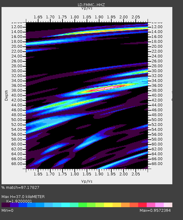
| Estimated Moho Depth: |
37.0 km |
| Estimated Crust Vp/Vs: |
1.92 |
| Assumed Crust Vp: |
6.121 km/s |
| Estimated Crust Vs: |
3.188 km/s |
| Estimated Crust Poisson's Ratio: |
0.31 |
|
| Radial Match: |
97.17827 % |
| Radial Bump: |
351 |
| Transverse Match: |
94.46715 % |
| Transverse Bump: |
400 |
| SOD ConfigId: |
13570011 |
| Insert Time: |
2019-04-29 14:59:07.555 +0000 |
| GWidth: |
2.5 |
| Max Bumps: |
400 |
| Tol: |
0.001 |
|
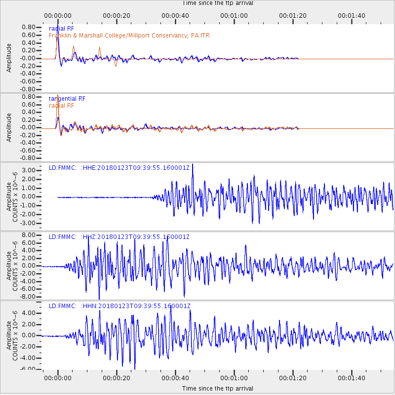
Signal To Noise
| Channel | StoN | STA | LTA |
| LD:FMMC: :HHZ:20180123T09:39:55.160001Z | 22.607412 | 3.4838231E-7 | 1.5410093E-8 |
| LD:FMMC: :HHN:20180123T09:39:55.160001Z | 7.3128037 | 1.2649124E-7 | 1.7297229E-8 |
| LD:FMMC: :HHE:20180123T09:39:55.160001Z | 6.5046854 | 1.0038934E-7 | 1.543339E-8 |
| Arrivals |
| Ps | 5.8 SECOND |
| PpPs | 17 SECOND |
| PsPs/PpSs | 23 SECOND |


