You are here: Home > Network List > LD - Lamont-Doherty Cooperative Seismographic Network Stations List
> Station GEDE Greenville, DE, USA > Earthquake Result Viewer
GEDE Greenville, DE, USA - Earthquake Result Viewer
| Earthquake location: |
Gulf Of Alaska |
| Earthquake latitude/longitude: |
56.0/-149.1 |
| Earthquake time(UTC): |
2018/01/23 (023) 09:31:42 GMT |
| Earthquake Depth: |
25 km |
| Earthquake Magnitude: |
7.9 Mww |
| Earthquake Catalog/Contributor: |
NEIC PDE/us |
|
| Network: |
LD Lamont-Doherty Cooperative Seismographic Network |
| Station: |
GEDE Greenville, DE, USA |
| Lat/Lon: |
39.81 N/75.64 W |
| Elevation: |
105 m |
|
| Distance: |
49.4 deg |
| Az: |
76.587 deg |
| Baz: |
314.88 deg |
| Ray Param: |
0.06869978 |
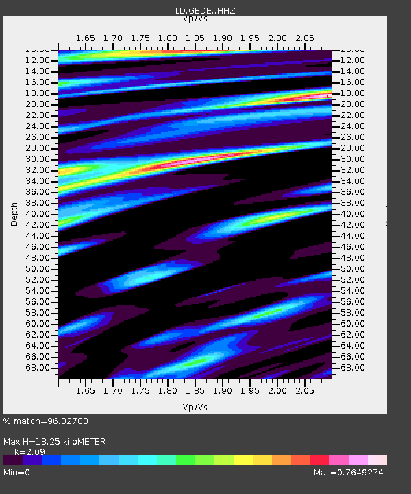
| Estimated Moho Depth: |
18.25 km |
| Estimated Crust Vp/Vs: |
2.09 |
| Assumed Crust Vp: |
6.287 km/s |
| Estimated Crust Vs: |
3.008 km/s |
| Estimated Crust Poisson's Ratio: |
0.35 |
|
| Radial Match: |
96.82783 % |
| Radial Bump: |
358 |
| Transverse Match: |
87.68998 % |
| Transverse Bump: |
400 |
| SOD ConfigId: |
13570011 |
| Insert Time: |
2019-04-29 14:59:09.894 +0000 |
| GWidth: |
2.5 |
| Max Bumps: |
400 |
| Tol: |
0.001 |
|
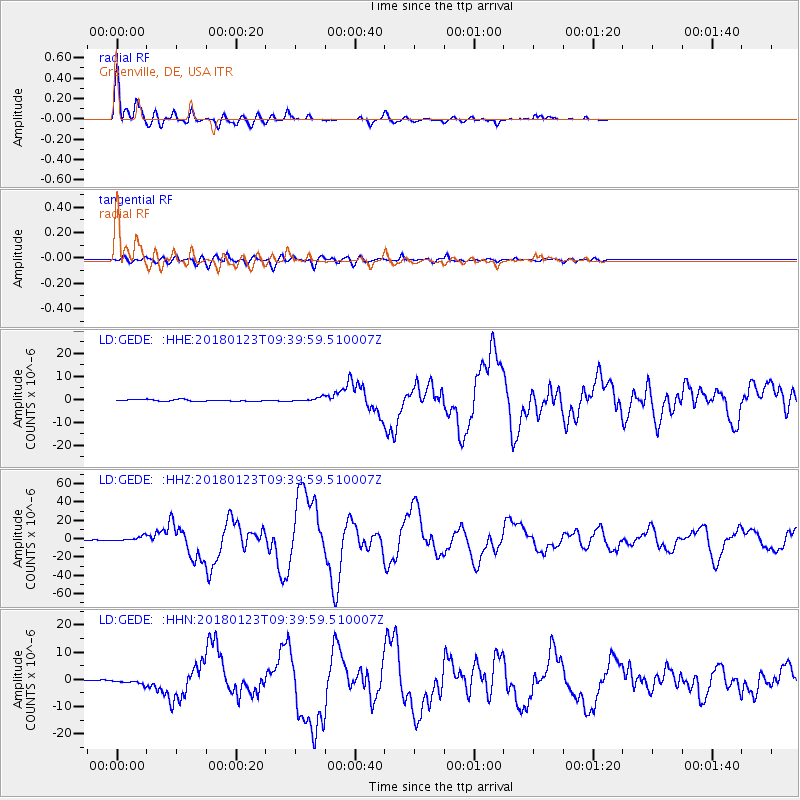
Signal To Noise
| Channel | StoN | STA | LTA |
| LD:GEDE: :HHZ:20180123T09:39:59.510007Z | 9.83191 | 2.602596E-6 | 2.647091E-7 |
| LD:GEDE: :HHN:20180123T09:39:59.510007Z | 4.42901 | 8.229075E-7 | 1.8579942E-7 |
| LD:GEDE: :HHE:20180123T09:39:59.510007Z | 2.465738 | 8.711767E-7 | 3.5331277E-7 |
| Arrivals |
| Ps | 3.3 SECOND |
| PpPs | 8.6 SECOND |
| PsPs/PpSs | 12 SECOND |


