You are here: Home > Network List > LD - Lamont-Doherty Cooperative Seismographic Network Stations List
> Station MCVT Middlebury College, Vermont > Earthquake Result Viewer
MCVT Middlebury College, Vermont - Earthquake Result Viewer
| Earthquake location: |
Gulf Of Alaska |
| Earthquake latitude/longitude: |
56.0/-149.1 |
| Earthquake time(UTC): |
2018/01/23 (023) 09:31:42 GMT |
| Earthquake Depth: |
25 km |
| Earthquake Magnitude: |
7.9 Mww |
| Earthquake Catalog/Contributor: |
NEIC PDE/us |
|
| Network: |
LD Lamont-Doherty Cooperative Seismographic Network |
| Station: |
MCVT Middlebury College, Vermont |
| Lat/Lon: |
43.95 N/72.99 W |
| Elevation: |
439 m |
|
| Distance: |
47.9 deg |
| Az: |
70.788 deg |
| Baz: |
312.808 deg |
| Ray Param: |
0.06963856 |
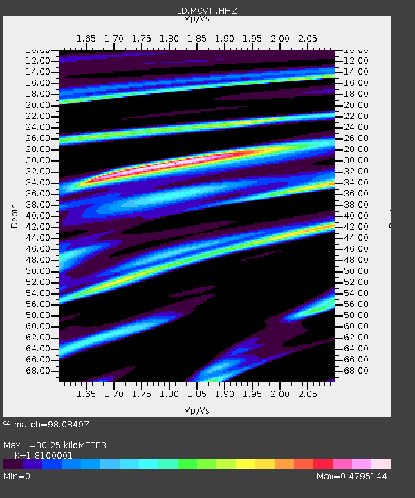
| Estimated Moho Depth: |
30.25 km |
| Estimated Crust Vp/Vs: |
1.81 |
| Assumed Crust Vp: |
6.419 km/s |
| Estimated Crust Vs: |
3.547 km/s |
| Estimated Crust Poisson's Ratio: |
0.28 |
|
| Radial Match: |
98.08497 % |
| Radial Bump: |
339 |
| Transverse Match: |
93.829094 % |
| Transverse Bump: |
400 |
| SOD ConfigId: |
13570011 |
| Insert Time: |
2019-04-29 14:59:12.898 +0000 |
| GWidth: |
2.5 |
| Max Bumps: |
400 |
| Tol: |
0.001 |
|

Signal To Noise
| Channel | StoN | STA | LTA |
| LD:MCVT: :HHZ:20180123T09:39:48.424985Z | 3.4684434 | 1.2228354E-6 | 3.525603E-7 |
| LD:MCVT: :HHN:20180123T09:39:48.424985Z | 2.0934947 | 6.019951E-7 | 2.8755514E-7 |
| LD:MCVT: :HHE:20180123T09:39:48.424985Z | 1.3569258 | 6.0220094E-7 | 4.4379797E-7 |
| Arrivals |
| Ps | 4.0 SECOND |
| PpPs | 12 SECOND |
| PsPs/PpSs | 17 SECOND |


