You are here: Home > Network List > LD - Lamont-Doherty Cooperative Seismographic Network Stations List
> Station ODNJ Ogdensburg, New Jersey > Earthquake Result Viewer
ODNJ Ogdensburg, New Jersey - Earthquake Result Viewer
| Earthquake location: |
Gulf Of Alaska |
| Earthquake latitude/longitude: |
56.0/-149.1 |
| Earthquake time(UTC): |
2018/01/23 (023) 09:31:42 GMT |
| Earthquake Depth: |
25 km |
| Earthquake Magnitude: |
7.9 Mww |
| Earthquake Catalog/Contributor: |
NEIC PDE/us |
|
| Network: |
LD Lamont-Doherty Cooperative Seismographic Network |
| Station: |
ODNJ Ogdensburg, New Jersey |
| Lat/Lon: |
41.08 N/74.61 W |
| Elevation: |
187 m |
|
| Distance: |
49.0 deg |
| Az: |
74.663 deg |
| Baz: |
314.289 deg |
| Ray Param: |
0.068914466 |
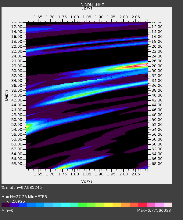
| Estimated Moho Depth: |
27.25 km |
| Estimated Crust Vp/Vs: |
2.09 |
| Assumed Crust Vp: |
6.283 km/s |
| Estimated Crust Vs: |
3.003 km/s |
| Estimated Crust Poisson's Ratio: |
0.35 |
|
| Radial Match: |
97.985245 % |
| Radial Bump: |
242 |
| Transverse Match: |
91.41342 % |
| Transverse Bump: |
400 |
| SOD ConfigId: |
13570011 |
| Insert Time: |
2019-04-29 14:59:15.570 +0000 |
| GWidth: |
2.5 |
| Max Bumps: |
400 |
| Tol: |
0.001 |
|

Signal To Noise
| Channel | StoN | STA | LTA |
| LD:ODNJ: :HHZ:20180123T09:39:56.977994Z | 7.437234 | 1.9026633E-6 | 2.5582943E-7 |
| LD:ODNJ: :HHN:20180123T09:39:56.977994Z | 2.4788358 | 7.5735437E-7 | 3.0552826E-7 |
| LD:ODNJ: :HHE:20180123T09:39:56.977994Z | 1.8825885 | 7.0778384E-7 | 3.759631E-7 |
| Arrivals |
| Ps | 5.0 SECOND |
| PpPs | 13 SECOND |
| PsPs/PpSs | 18 SECOND |


