You are here: Home > Network List > US - United States National Seismic Network Stations List
> Station ELK Elko, Nevada, USA > Earthquake Result Viewer
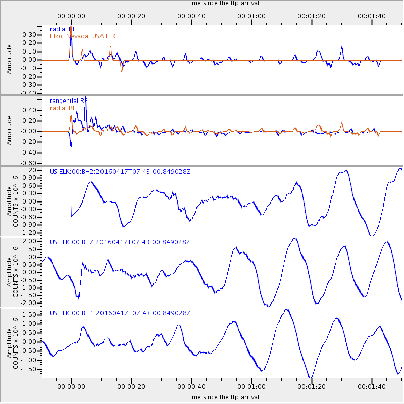
ELK Elko, Nevada, USA - Earthquake Result Viewer
*The percent match for this event was below the threshold and hence no stack was calculated.
| Earthquake location: |
Tonga Islands Region |
| Earthquake latitude/longitude: |
-23.6/-174.3 |
| Earthquake time(UTC): |
2016/04/17 (108) 07:31:03 GMT |
| Earthquake Depth: |
35 km |
| Earthquake Magnitude: |
5.8 MB |
| Earthquake Catalog/Contributor: |
NEIC PDE/NEIC COMCAT |
|
| Network: |
US United States National Seismic Network |
| Station: |
ELK Elko, Nevada, USA |
| Lat/Lon: |
40.74 N/115.24 W |
| Elevation: |
2210 m |
|
| Distance: |
84.3 deg |
| Az: |
40.926 deg |
| Baz: |
232.273 deg |
| Ray Param: |
$rayparam |
*The percent match for this event was below the threshold and hence was not used in the summary stack. |
|
| Radial Match: |
51.730053 % |
| Radial Bump: |
400 |
| Transverse Match: |
94.4852 % |
| Transverse Bump: |
331 |
| SOD ConfigId: |
1475611 |
| Insert Time: |
2016-05-01 07:41:11.806 +0000 |
| GWidth: |
2.5 |
| Max Bumps: |
400 |
| Tol: |
0.001 |
|
Signal To Noise
| Channel | StoN | STA | LTA |
| US:ELK:00:BHZ:20160417T07:43:00.849028Z | 1.7990078 | 9.739559E-7 | 5.413851E-7 |
| US:ELK:00:BH1:20160417T07:43:00.849028Z | 1.3311838 | 4.6662257E-7 | 3.5053205E-7 |
| US:ELK:00:BH2:20160417T07:43:00.849028Z | 0.7831183 | 3.5987546E-7 | 4.595416E-7 |
| Arrivals |
| Ps | |
| PpPs | |
| PsPs/PpSs | |


