You are here: Home > Network List > TA - USArray Transportable Network (new EarthScope stations) Stations List
> Station T23A Casias Ranch, Antonito, CO, USA > Earthquake Result Viewer
T23A Casias Ranch, Antonito, CO, USA - Earthquake Result Viewer

| Earthquake location: |
Panama |
| Earthquake latitude/longitude: |
9.6/-79.0 |
| Earthquake time(UTC): |
2009/07/04 (185) 06:49:35 GMT |
| Earthquake Depth: |
38 km |
| Earthquake Magnitude: |
6.0 MB, 5.5 MS, 6.0 MW, 6.0 MW |
| Earthquake Catalog/Contributor: |
WHDF/NEIC |
|
| Network: |
TA USArray Transportable Network (new EarthScope stations) |
| Station: |
T23A Casias Ranch, Antonito, CO, USA |
| Lat/Lon: |
37.04 N/106.04 W |
| Elevation: |
2429 m |
|
| Distance: |
36.7 deg |
| Az: |
322.438 deg |
| Baz: |
131.295 deg |
| Ray Param: |
0.07646923 |
| Estimated Moho Depth: |
35.5 km |
| Estimated Crust Vp/Vs: |
2.10 |
| Assumed Crust Vp: |
6.159 km/s |
| Estimated Crust Vs: |
2.936 km/s |
| Estimated Crust Poisson's Ratio: |
0.35 |
|
| Radial Match: |
81.457985 % |
| Radial Bump: |
332 |
| Transverse Match: |
69.538704 % |
| Transverse Bump: |
400 |
| SOD ConfigId: |
2648 |
| Insert Time: |
2010-03-06 08:13:00.424 +0000 |
| GWidth: |
2.5 |
| Max Bumps: |
400 |
| Tol: |
0.001 |
|
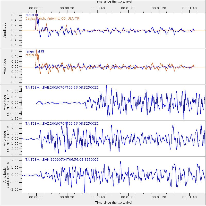
Signal To Noise
| Channel | StoN | STA | LTA |
| TA:T23A: :BHZ:20090704T06:56:08.325002Z | 13.028638 | 8.50528E-7 | 6.528142E-8 |
| TA:T23A: :BHN:20090704T06:56:08.325002Z | 3.7886019 | 2.3680349E-7 | 6.250419E-8 |
| TA:T23A: :BHE:20090704T06:56:08.325002Z | 3.8902888 | 2.1247776E-7 | 5.4617477E-8 |
| Arrivals |
| Ps | 6.7 SECOND |
| PpPs | 17 SECOND |
| PsPs/PpSs | 24 SECOND |


