You are here: Home > Network List > N4 - Central and EAstern US Network Stations List
> Station 553A Crawfordville, FL, USA > Earthquake Result Viewer
553A Crawfordville, FL, USA - Earthquake Result Viewer
| Earthquake location: |
Gulf Of Alaska |
| Earthquake latitude/longitude: |
56.0/-149.1 |
| Earthquake time(UTC): |
2018/01/23 (023) 09:31:42 GMT |
| Earthquake Depth: |
25 km |
| Earthquake Magnitude: |
7.9 Mww |
| Earthquake Catalog/Contributor: |
NEIC PDE/us |
|
| Network: |
N4 Central and EAstern US Network |
| Station: |
553A Crawfordville, FL, USA |
| Lat/Lon: |
30.19 N/84.43 W |
| Elevation: |
16 m |
|
| Distance: |
51.5 deg |
| Az: |
91.919 deg |
| Baz: |
319.633 deg |
| Ray Param: |
0.06732084 |
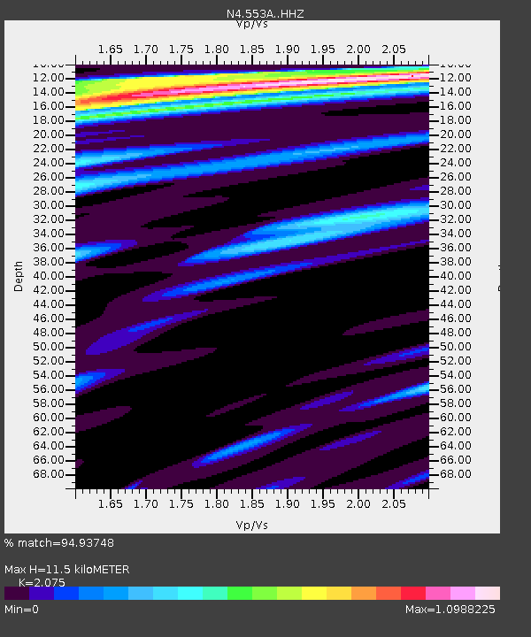
| Estimated Moho Depth: |
11.5 km |
| Estimated Crust Vp/Vs: |
2.08 |
| Assumed Crust Vp: |
6.347 km/s |
| Estimated Crust Vs: |
3.059 km/s |
| Estimated Crust Poisson's Ratio: |
0.35 |
|
| Radial Match: |
94.93748 % |
| Radial Bump: |
321 |
| Transverse Match: |
87.147095 % |
| Transverse Bump: |
363 |
| SOD ConfigId: |
13570011 |
| Insert Time: |
2019-04-29 14:59:52.209 +0000 |
| GWidth: |
2.5 |
| Max Bumps: |
400 |
| Tol: |
0.001 |
|

Signal To Noise
| Channel | StoN | STA | LTA |
| N4:553A: :HHZ:20180123T09:40:15.690Z | 11.7973385 | 9.100984E-6 | 7.714438E-7 |
| N4:553A: :HHN:20180123T09:40:15.690Z | 6.109713 | 2.8658744E-6 | 4.690686E-7 |
| N4:553A: :HHE:20180123T09:40:15.690Z | 3.1978278 | 2.5480836E-6 | 7.96817E-7 |
| Arrivals |
| Ps | 2.0 SECOND |
| PpPs | 5.3 SECOND |
| PsPs/PpSs | 7.4 SECOND |


