You are here: Home > Network List > N4 - Central and EAstern US Network Stations List
> Station D41A Chassel, MI, USA > Earthquake Result Viewer
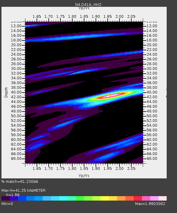
D41A Chassel, MI, USA - Earthquake Result Viewer
| Earthquake location: |
Gulf Of Alaska |
| Earthquake latitude/longitude: |
56.0/-149.1 |
| Earthquake time(UTC): |
2018/01/23 (023) 09:31:42 GMT |
| Earthquake Depth: |
25 km |
| Earthquake Magnitude: |
7.9 Mww |
| Earthquake Catalog/Contributor: |
NEIC PDE/us |
|
| Network: |
N4 Central and EAstern US Network |
| Station: |
D41A Chassel, MI, USA |
| Lat/Lon: |
47.06 N/88.57 W |
| Elevation: |
271 m |
|
| Distance: |
37.5 deg |
| Az: |
77.596 deg |
| Baz: |
306.721 deg |
| Ray Param: |
0.07604206 |
| Estimated Moho Depth: |
41.25 km |
| Estimated Crust Vp/Vs: |
1.96 |
| Assumed Crust Vp: |
6.467 km/s |
| Estimated Crust Vs: |
3.299 km/s |
| Estimated Crust Poisson's Ratio: |
0.32 |
|
| Radial Match: |
91.23066 % |
| Radial Bump: |
316 |
| Transverse Match: |
66.273506 % |
| Transverse Bump: |
400 |
| SOD ConfigId: |
13570011 |
| Insert Time: |
2019-04-29 14:59:56.724 +0000 |
| GWidth: |
2.5 |
| Max Bumps: |
400 |
| Tol: |
0.001 |
|

Signal To Noise
| Channel | StoN | STA | LTA |
| N4:D41A: :HHZ:20180123T09:38:24.279996Z | 2.6765356 | 2.25789E-6 | 8.435867E-7 |
| N4:D41A: :HHN:20180123T09:38:24.279996Z | 1.3185393 | 8.560906E-7 | 6.49272E-7 |
| N4:D41A: :HHE:20180123T09:38:24.279996Z | 1.3988395 | 1.1242756E-6 | 8.0372024E-7 |
| Arrivals |
| Ps | 6.5 SECOND |
| PpPs | 18 SECOND |
| PsPs/PpSs | 24 SECOND |


