You are here: Home > Network List > US - United States National Seismic Network Stations List
> Station MIAR Mount Ida, Arkansas, USA > Earthquake Result Viewer
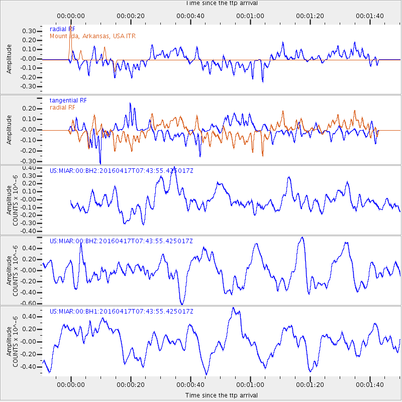
MIAR Mount Ida, Arkansas, USA - Earthquake Result Viewer
*The percent match for this event was below the threshold and hence no stack was calculated.
| Earthquake location: |
Tonga Islands Region |
| Earthquake latitude/longitude: |
-23.6/-174.3 |
| Earthquake time(UTC): |
2016/04/17 (108) 07:31:03 GMT |
| Earthquake Depth: |
35 km |
| Earthquake Magnitude: |
5.8 MB |
| Earthquake Catalog/Contributor: |
NEIC PDE/NEIC COMCAT |
|
| Network: |
US United States National Seismic Network |
| Station: |
MIAR Mount Ida, Arkansas, USA |
| Lat/Lon: |
34.55 N/93.58 W |
| Elevation: |
207 m |
|
| Distance: |
95.9 deg |
| Az: |
54.992 deg |
| Baz: |
245.541 deg |
| Ray Param: |
$rayparam |
*The percent match for this event was below the threshold and hence was not used in the summary stack. |
|
| Radial Match: |
54.887894 % |
| Radial Bump: |
400 |
| Transverse Match: |
59.268402 % |
| Transverse Bump: |
400 |
| SOD ConfigId: |
1475611 |
| Insert Time: |
2016-05-01 07:41:57.145 +0000 |
| GWidth: |
2.5 |
| Max Bumps: |
400 |
| Tol: |
0.001 |
|
Signal To Noise
| Channel | StoN | STA | LTA |
| US:MIAR:00:BHZ:20160417T07:43:55.425017Z | 1.3444335 | 2.384657E-7 | 1.7737263E-7 |
| US:MIAR:00:BH1:20160417T07:43:55.425017Z | 1.3602185 | 2.8365224E-7 | 2.085343E-7 |
| US:MIAR:00:BH2:20160417T07:43:55.425017Z | 3.1059659 | 3.439738E-7 | 1.1074616E-7 |
| Arrivals |
| Ps | |
| PpPs | |
| PsPs/PpSs | |


