You are here: Home > Network List > N4 - Central and EAstern US Network Stations List
> Station N41A Harden Midland Farm, Stronghurst, IL, USA > Earthquake Result Viewer
N41A Harden Midland Farm, Stronghurst, IL, USA - Earthquake Result Viewer
| Earthquake location: |
Gulf Of Alaska |
| Earthquake latitude/longitude: |
56.0/-149.1 |
| Earthquake time(UTC): |
2018/01/23 (023) 09:31:42 GMT |
| Earthquake Depth: |
25 km |
| Earthquake Magnitude: |
7.9 Mww |
| Earthquake Catalog/Contributor: |
NEIC PDE/us |
|
| Network: |
N4 Central and EAstern US Network |
| Station: |
N41A Harden Midland Farm, Stronghurst, IL, USA |
| Lat/Lon: |
40.71 N/90.86 W |
| Elevation: |
226 m |
|
| Distance: |
40.3 deg |
| Az: |
87.067 deg |
| Baz: |
312.513 deg |
| Ray Param: |
0.07442906 |
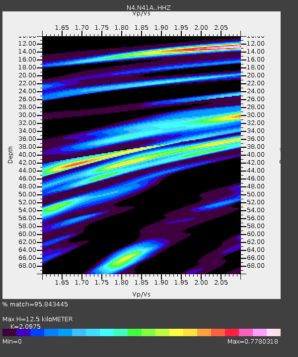
| Estimated Moho Depth: |
12.5 km |
| Estimated Crust Vp/Vs: |
2.10 |
| Assumed Crust Vp: |
6.498 km/s |
| Estimated Crust Vs: |
3.098 km/s |
| Estimated Crust Poisson's Ratio: |
0.35 |
|
| Radial Match: |
95.843445 % |
| Radial Bump: |
273 |
| Transverse Match: |
84.748825 % |
| Transverse Bump: |
400 |
| SOD ConfigId: |
13570011 |
| Insert Time: |
2019-04-29 15:00:46.840 +0000 |
| GWidth: |
2.5 |
| Max Bumps: |
400 |
| Tol: |
0.001 |
|

Signal To Noise
| Channel | StoN | STA | LTA |
| N4:N41A: :HHZ:20180123T09:38:47.529996Z | 14.842539 | 6.006931E-6 | 4.0471048E-7 |
| N4:N41A: :HHN:20180123T09:38:47.529996Z | 4.857437 | 2.4281608E-6 | 4.998852E-7 |
| N4:N41A: :HHE:20180123T09:38:47.529996Z | 8.766396 | 2.5465658E-6 | 2.9049178E-7 |
| Arrivals |
| Ps | 2.2 SECOND |
| PpPs | 5.6 SECOND |
| PsPs/PpSs | 7.9 SECOND |


