You are here: Home > Network List > N4 - Central and EAstern US Network Stations List
> Station P53A Whipple, OH, USA > Earthquake Result Viewer
P53A Whipple, OH, USA - Earthquake Result Viewer
| Earthquake location: |
Gulf Of Alaska |
| Earthquake latitude/longitude: |
56.0/-149.1 |
| Earthquake time(UTC): |
2018/01/23 (023) 09:31:42 GMT |
| Earthquake Depth: |
25 km |
| Earthquake Magnitude: |
7.9 Mww |
| Earthquake Catalog/Contributor: |
NEIC PDE/us |
|
| Network: |
N4 Central and EAstern US Network |
| Station: |
P53A Whipple, OH, USA |
| Lat/Lon: |
39.49 N/81.39 W |
| Elevation: |
270 m |
|
| Distance: |
46.4 deg |
| Az: |
81.098 deg |
| Baz: |
314.247 deg |
| Ray Param: |
0.07060464 |
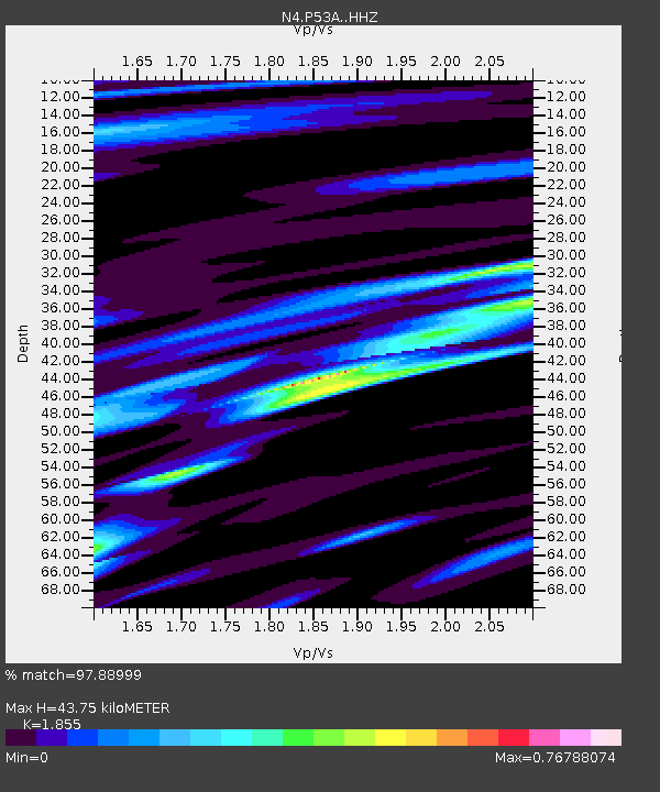
| Estimated Moho Depth: |
43.75 km |
| Estimated Crust Vp/Vs: |
1.86 |
| Assumed Crust Vp: |
6.207 km/s |
| Estimated Crust Vs: |
3.346 km/s |
| Estimated Crust Poisson's Ratio: |
0.30 |
|
| Radial Match: |
97.88999 % |
| Radial Bump: |
269 |
| Transverse Match: |
91.32511 % |
| Transverse Bump: |
400 |
| SOD ConfigId: |
13570011 |
| Insert Time: |
2019-04-29 15:00:58.801 +0000 |
| GWidth: |
2.5 |
| Max Bumps: |
400 |
| Tol: |
0.001 |
|

Signal To Noise
| Channel | StoN | STA | LTA |
| N4:P53A: :HHZ:20180123T09:39:36.790006Z | 9.579836 | 4.463331E-6 | 4.6590895E-7 |
| N4:P53A: :HHN:20180123T09:39:36.790006Z | 4.300648 | 1.5763537E-6 | 3.6653864E-7 |
| N4:P53A: :HHE:20180123T09:39:36.790006Z | 4.247707 | 1.7633192E-6 | 4.1512263E-7 |
| Arrivals |
| Ps | 6.4 SECOND |
| PpPs | 19 SECOND |
| PsPs/PpSs | 25 SECOND |


