You are here: Home > Network List > NE - New England Seismic Network Stations List
> Station WVL Waterville, ME, USA > Earthquake Result Viewer
WVL Waterville, ME, USA - Earthquake Result Viewer
| Earthquake location: |
Gulf Of Alaska |
| Earthquake latitude/longitude: |
56.0/-149.1 |
| Earthquake time(UTC): |
2018/01/23 (023) 09:31:42 GMT |
| Earthquake Depth: |
25 km |
| Earthquake Magnitude: |
7.9 Mww |
| Earthquake Catalog/Contributor: |
NEIC PDE/us |
|
| Network: |
NE New England Seismic Network |
| Station: |
WVL Waterville, ME, USA |
| Lat/Lon: |
44.56 N/69.66 W |
| Elevation: |
50 m |
|
| Distance: |
49.3 deg |
| Az: |
68.016 deg |
| Baz: |
313.29 deg |
| Ray Param: |
0.06877089 |
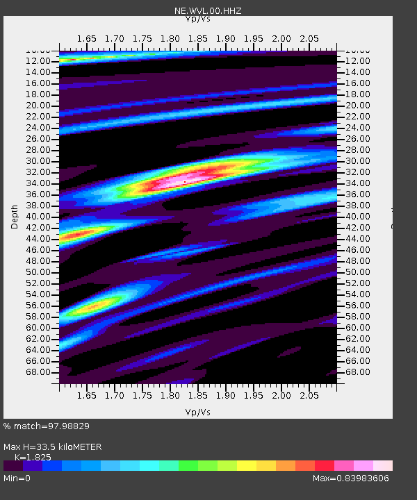
| Estimated Moho Depth: |
33.5 km |
| Estimated Crust Vp/Vs: |
1.83 |
| Assumed Crust Vp: |
6.419 km/s |
| Estimated Crust Vs: |
3.517 km/s |
| Estimated Crust Poisson's Ratio: |
0.29 |
|
| Radial Match: |
97.98829 % |
| Radial Bump: |
400 |
| Transverse Match: |
87.759674 % |
| Transverse Bump: |
400 |
| SOD ConfigId: |
13570011 |
| Insert Time: |
2019-04-29 15:01:44.273 +0000 |
| GWidth: |
2.5 |
| Max Bumps: |
400 |
| Tol: |
0.001 |
|

Signal To Noise
| Channel | StoN | STA | LTA |
| NE:WVL:00:HHZ:20180123T09:39:58.653013Z | 4.1983433 | 2.1627102E-6 | 5.1513416E-7 |
| NE:WVL:00:HH1:20180123T09:39:58.653013Z | 2.6022637 | 7.7500925E-7 | 2.978212E-7 |
| NE:WVL:00:HH2:20180123T09:39:58.653013Z | 1.4370263 | 6.370807E-7 | 4.4333268E-7 |
| Arrivals |
| Ps | 4.6 SECOND |
| PpPs | 14 SECOND |
| PsPs/PpSs | 18 SECOND |


