You are here: Home > Network List > OH - Ohio Seismic Network Stations List
> Station LEBO Lake Erie Bluffs Ohio > Earthquake Result Viewer
LEBO Lake Erie Bluffs Ohio - Earthquake Result Viewer
| Earthquake location: |
Gulf Of Alaska |
| Earthquake latitude/longitude: |
56.0/-149.1 |
| Earthquake time(UTC): |
2018/01/23 (023) 09:31:42 GMT |
| Earthquake Depth: |
25 km |
| Earthquake Magnitude: |
7.9 Mww |
| Earthquake Catalog/Contributor: |
NEIC PDE/us |
|
| Network: |
OH Ohio Seismic Network |
| Station: |
LEBO Lake Erie Bluffs Ohio |
| Lat/Lon: |
41.79 N/81.18 W |
| Elevation: |
188 m |
|
| Distance: |
45.0 deg |
| Az: |
78.615 deg |
| Baz: |
312.649 deg |
| Ray Param: |
0.07154153 |
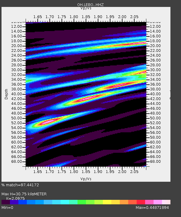
| Estimated Moho Depth: |
30.75 km |
| Estimated Crust Vp/Vs: |
2.10 |
| Assumed Crust Vp: |
6.483 km/s |
| Estimated Crust Vs: |
3.091 km/s |
| Estimated Crust Poisson's Ratio: |
0.35 |
|
| Radial Match: |
97.44172 % |
| Radial Bump: |
305 |
| Transverse Match: |
89.14874 % |
| Transverse Bump: |
400 |
| SOD ConfigId: |
13570011 |
| Insert Time: |
2019-04-29 15:02:15.141 +0000 |
| GWidth: |
2.5 |
| Max Bumps: |
400 |
| Tol: |
0.001 |
|

Signal To Noise
| Channel | StoN | STA | LTA |
| OH:LEBO: :HHZ:20180123T09:39:25.239988Z | 7.1825666 | 2.4397166E-6 | 3.3967197E-7 |
| OH:LEBO: :HHN:20180123T09:39:25.239988Z | 3.0977163 | 1.0616659E-6 | 3.4272534E-7 |
| OH:LEBO: :HHE:20180123T09:39:25.239988Z | 5.429238 | 1.3593675E-6 | 2.503791E-7 |
| Arrivals |
| Ps | 5.5 SECOND |
| PpPs | 14 SECOND |
| PsPs/PpSs | 19 SECOND |


