You are here: Home > Network List > UU - University of Utah Regional Network Stations List
> Station FORU South Mineral Mountains, UT, USA > Earthquake Result Viewer
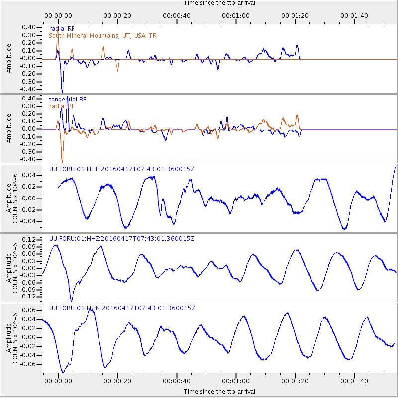
FORU South Mineral Mountains, UT, USA - Earthquake Result Viewer
*The percent match for this event was below the threshold and hence no stack was calculated.
| Earthquake location: |
Tonga Islands Region |
| Earthquake latitude/longitude: |
-23.6/-174.3 |
| Earthquake time(UTC): |
2016/04/17 (108) 07:31:03 GMT |
| Earthquake Depth: |
35 km |
| Earthquake Magnitude: |
5.8 MB |
| Earthquake Catalog/Contributor: |
NEIC PDE/NEIC COMCAT |
|
| Network: |
UU University of Utah Regional Network |
| Station: |
FORU South Mineral Mountains, UT, USA |
| Lat/Lon: |
38.46 N/112.86 W |
| Elevation: |
1840 m |
|
| Distance: |
84.4 deg |
| Az: |
43.869 deg |
| Baz: |
234.073 deg |
| Ray Param: |
$rayparam |
*The percent match for this event was below the threshold and hence was not used in the summary stack. |
|
| Radial Match: |
44.214897 % |
| Radial Bump: |
400 |
| Transverse Match: |
89.33733 % |
| Transverse Bump: |
374 |
| SOD ConfigId: |
1475611 |
| Insert Time: |
2016-05-01 07:42:50.713 +0000 |
| GWidth: |
2.5 |
| Max Bumps: |
400 |
| Tol: |
0.001 |
|
Signal To Noise
| Channel | StoN | STA | LTA |
| UU:FORU:01:HHZ:20160417T07:43:01.360015Z | 1.7212944 | 7.882223E-8 | 4.5792415E-8 |
| UU:FORU:01:HHN:20160417T07:43:01.360015Z | 1.5344932 | 5.6962357E-8 | 3.7121286E-8 |
| UU:FORU:01:HHE:20160417T07:43:01.360015Z | 1.1385727 | 3.0922145E-8 | 2.715869E-8 |
| Arrivals |
| Ps | |
| PpPs | |
| PsPs/PpSs | |


