You are here: Home > Network List > TA - USArray Transportable Network (new EarthScope stations) Stations List
> Station T23A Casias Ranch, Antonito, CO, USA > Earthquake Result Viewer
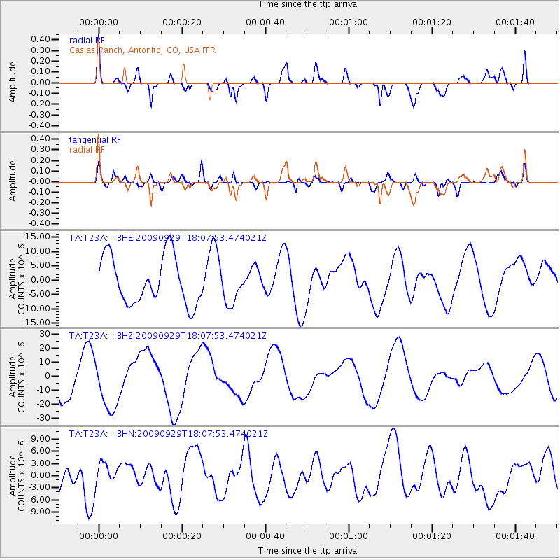
T23A Casias Ranch, Antonito, CO, USA - Earthquake Result Viewer
*The percent match for this event was below the threshold and hence no stack was calculated.
| Earthquake location: |
Tonga Islands |
| Earthquake latitude/longitude: |
-15.4/-173.2 |
| Earthquake time(UTC): |
2009/09/29 (272) 17:56:05 GMT |
| Earthquake Depth: |
10 km |
| Earthquake Magnitude: |
6.0 MB |
| Earthquake Catalog/Contributor: |
WHDF/NEIC |
|
| Network: |
TA USArray Transportable Network (new EarthScope stations) |
| Station: |
T23A Casias Ranch, Antonito, CO, USA |
| Lat/Lon: |
37.04 N/106.04 W |
| Elevation: |
2429 m |
|
| Distance: |
81.8 deg |
| Az: |
48.144 deg |
| Baz: |
243.897 deg |
| Ray Param: |
$rayparam |
*The percent match for this event was below the threshold and hence was not used in the summary stack. |
|
| Radial Match: |
62.75341 % |
| Radial Bump: |
400 |
| Transverse Match: |
45.62237 % |
| Transverse Bump: |
400 |
| SOD ConfigId: |
2622 |
| Insert Time: |
2010-03-06 08:14:00.353 +0000 |
| GWidth: |
2.5 |
| Max Bumps: |
400 |
| Tol: |
0.001 |
|
Signal To Noise
| Channel | StoN | STA | LTA |
| TA:T23A: :BHZ:20090929T18:07:53.474021Z | 1.7557061 | 1.7921835E-5 | 1.0207765E-5 |
| TA:T23A: :BHN:20090929T18:07:53.474021Z | 0.43611598 | 2.4153073E-6 | 5.538223E-6 |
| TA:T23A: :BHE:20090929T18:07:53.474021Z | 0.73855674 | 6.14485E-6 | 8.320078E-6 |
| Arrivals |
| Ps | |
| PpPs | |
| PsPs/PpSs | |


