You are here: Home > Network List > TA - USArray Transportable Network (new EarthScope stations) Stations List
> Station T23A Casias Ranch, Antonito, CO, USA > Earthquake Result Viewer
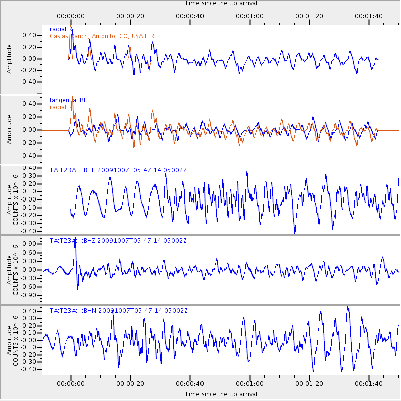
T23A Casias Ranch, Antonito, CO, USA - Earthquake Result Viewer
*The percent match for this event was below the threshold and hence no stack was calculated.
| Earthquake location: |
Rat Islands, Aleutian Islands |
| Earthquake latitude/longitude: |
52.2/178.1 |
| Earthquake time(UTC): |
2009/10/07 (280) 05:38:37 GMT |
| Earthquake Depth: |
138 km |
| Earthquake Magnitude: |
5.6 MB, 5.6 MW, 5.6 MW |
| Earthquake Catalog/Contributor: |
WHDF/NEIC |
|
| Network: |
TA USArray Transportable Network (new EarthScope stations) |
| Station: |
T23A Casias Ranch, Antonito, CO, USA |
| Lat/Lon: |
37.04 N/106.04 W |
| Elevation: |
2429 m |
|
| Distance: |
53.7 deg |
| Az: |
74.445 deg |
| Baz: |
312.124 deg |
| Ray Param: |
$rayparam |
*The percent match for this event was below the threshold and hence was not used in the summary stack. |
|
| Radial Match: |
65.81575 % |
| Radial Bump: |
400 |
| Transverse Match: |
57.655827 % |
| Transverse Bump: |
340 |
| SOD ConfigId: |
2622 |
| Insert Time: |
2010-03-06 08:14:06.293 +0000 |
| GWidth: |
2.5 |
| Max Bumps: |
400 |
| Tol: |
0.001 |
|
Signal To Noise
| Channel | StoN | STA | LTA |
| TA:T23A: :BHZ:20091007T05:47:14.05002Z | 6.3357396 | 4.042406E-7 | 6.380322E-8 |
| TA:T23A: :BHN:20091007T05:47:14.05002Z | 0.62338054 | 8.708665E-8 | 1.3970063E-7 |
| TA:T23A: :BHE:20091007T05:47:14.05002Z | 1.1390736 | 1.560115E-7 | 1.3696348E-7 |
| Arrivals |
| Ps | |
| PpPs | |
| PsPs/PpSs | |


