You are here: Home > Network List > PE - Penn State Network Stations List
> Station PACW Cowans Gap State Park, Fort Loudon, PA > Earthquake Result Viewer
PACW Cowans Gap State Park, Fort Loudon, PA - Earthquake Result Viewer
| Earthquake location: |
Gulf Of Alaska |
| Earthquake latitude/longitude: |
56.0/-149.1 |
| Earthquake time(UTC): |
2018/01/23 (023) 09:31:42 GMT |
| Earthquake Depth: |
25 km |
| Earthquake Magnitude: |
7.9 Mww |
| Earthquake Catalog/Contributor: |
NEIC PDE/us |
|
| Network: |
PE Penn State Network |
| Station: |
PACW Cowans Gap State Park, Fort Loudon, PA |
| Lat/Lon: |
40.00 N/77.92 W |
| Elevation: |
394 m |
|
| Distance: |
48.0 deg |
| Az: |
78.06 deg |
| Baz: |
314.39 deg |
| Ray Param: |
0.06960004 |
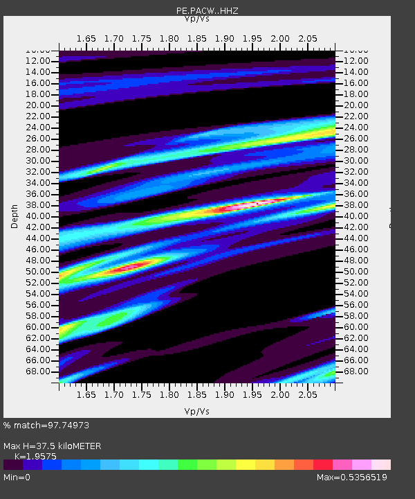
| Estimated Moho Depth: |
37.5 km |
| Estimated Crust Vp/Vs: |
1.96 |
| Assumed Crust Vp: |
6.419 km/s |
| Estimated Crust Vs: |
3.279 km/s |
| Estimated Crust Poisson's Ratio: |
0.32 |
|
| Radial Match: |
97.74973 % |
| Radial Bump: |
242 |
| Transverse Match: |
86.65944 % |
| Transverse Bump: |
400 |
| SOD ConfigId: |
13570011 |
| Insert Time: |
2019-04-29 15:03:05.966 +0000 |
| GWidth: |
2.5 |
| Max Bumps: |
400 |
| Tol: |
0.001 |
|

Signal To Noise
| Channel | StoN | STA | LTA |
| PE:PACW: :HHZ:20180123T09:39:48.904996Z | 14.204979 | 2.8740608E-6 | 2.0232771E-7 |
| PE:PACW: :HHN:20180123T09:39:48.904996Z | 5.221706 | 1.4777752E-6 | 2.8300622E-7 |
| PE:PACW: :HHE:20180123T09:39:48.904996Z | 2.6812336 | 1.5446906E-6 | 5.7611186E-7 |
| Arrivals |
| Ps | 5.9 SECOND |
| PpPs | 16 SECOND |
| PsPs/PpSs | 22 SECOND |


