You are here: Home > Network List > PE - Penn State Network Stations List
> Station PAMR Moraine State Park, Slippery Rock, PA > Earthquake Result Viewer
PAMR Moraine State Park, Slippery Rock, PA - Earthquake Result Viewer
| Earthquake location: |
Gulf Of Alaska |
| Earthquake latitude/longitude: |
56.0/-149.1 |
| Earthquake time(UTC): |
2018/01/23 (023) 09:31:42 GMT |
| Earthquake Depth: |
25 km |
| Earthquake Magnitude: |
7.9 Mww |
| Earthquake Catalog/Contributor: |
NEIC PDE/us |
|
| Network: |
PE Penn State Network |
| Station: |
PAMR Moraine State Park, Slippery Rock, PA |
| Lat/Lon: |
40.94 N/80.10 W |
| Elevation: |
393 m |
|
| Distance: |
46.1 deg |
| Az: |
78.701 deg |
| Baz: |
313.423 deg |
| Ray Param: |
0.070785046 |
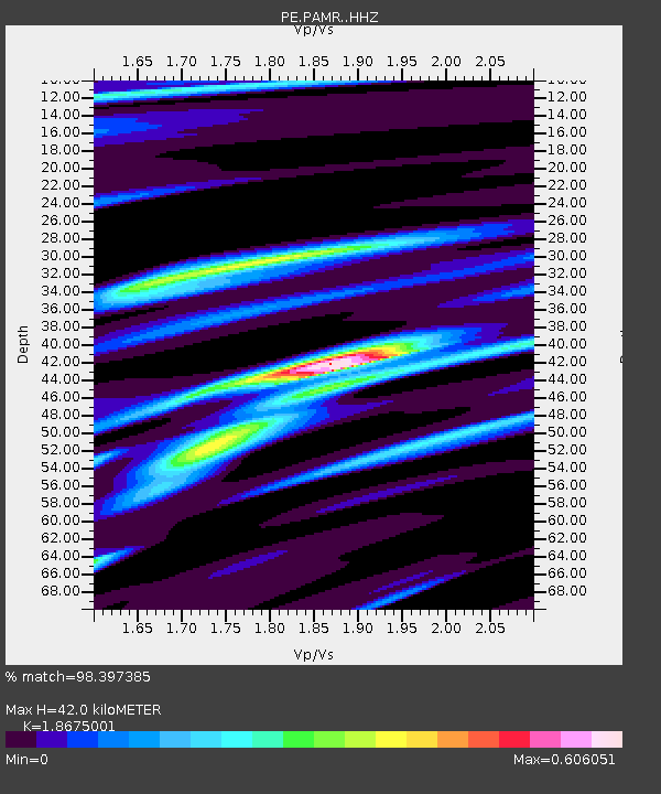
| Estimated Moho Depth: |
42.0 km |
| Estimated Crust Vp/Vs: |
1.87 |
| Assumed Crust Vp: |
6.483 km/s |
| Estimated Crust Vs: |
3.471 km/s |
| Estimated Crust Poisson's Ratio: |
0.30 |
|
| Radial Match: |
98.397385 % |
| Radial Bump: |
173 |
| Transverse Match: |
87.205765 % |
| Transverse Bump: |
400 |
| SOD ConfigId: |
13570011 |
| Insert Time: |
2019-04-29 15:03:10.285 +0000 |
| GWidth: |
2.5 |
| Max Bumps: |
400 |
| Tol: |
0.001 |
|

Signal To Noise
| Channel | StoN | STA | LTA |
| PE:PAMR: :HHZ:20180123T09:39:34.510007Z | 8.800877 | 3.0603303E-6 | 3.4773015E-7 |
| PE:PAMR: :HHN:20180123T09:39:34.510007Z | 4.078457 | 1.2644671E-6 | 3.1003566E-7 |
| PE:PAMR: :HHE:20180123T09:39:34.510007Z | 4.8429804 | 1.3465851E-6 | 2.7804884E-7 |
| Arrivals |
| Ps | 6.0 SECOND |
| PpPs | 17 SECOND |
| PsPs/PpSs | 23 SECOND |


