You are here: Home > Network List > WY - Yellowstone Wyoming Seismic Network Stations List
> Station YHH Holmes Hill, YNP, WY, USA > Earthquake Result Viewer
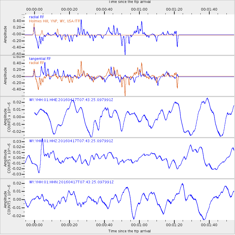
YHH Holmes Hill, YNP, WY, USA - Earthquake Result Viewer
*The percent match for this event was below the threshold and hence no stack was calculated.
| Earthquake location: |
Tonga Islands Region |
| Earthquake latitude/longitude: |
-23.6/-174.3 |
| Earthquake time(UTC): |
2016/04/17 (108) 07:31:03 GMT |
| Earthquake Depth: |
35 km |
| Earthquake Magnitude: |
5.8 MB |
| Earthquake Catalog/Contributor: |
NEIC PDE/NEIC COMCAT |
|
| Network: |
WY Yellowstone Wyoming Seismic Network |
| Station: |
YHH Holmes Hill, YNP, WY, USA |
| Lat/Lon: |
44.79 N/110.85 W |
| Elevation: |
2717 m |
|
| Distance: |
89.3 deg |
| Az: |
39.581 deg |
| Baz: |
235.17 deg |
| Ray Param: |
$rayparam |
*The percent match for this event was below the threshold and hence was not used in the summary stack. |
|
| Radial Match: |
67.15505 % |
| Radial Bump: |
262 |
| Transverse Match: |
78.17914 % |
| Transverse Bump: |
268 |
| SOD ConfigId: |
1475611 |
| Insert Time: |
2016-05-01 07:43:39.627 +0000 |
| GWidth: |
2.5 |
| Max Bumps: |
400 |
| Tol: |
0.001 |
|
Signal To Noise
| Channel | StoN | STA | LTA |
| WY:YHH:01:HHZ:20160417T07:43:25.097991Z | 3.3877432 | 1.8973433E-8 | 5.600611E-9 |
| WY:YHH:01:HHN:20160417T07:43:25.097991Z | 0.6226096 | 3.328102E-9 | 5.3454072E-9 |
| WY:YHH:01:HHE:20160417T07:43:25.097991Z | 1.6694661 | 2.0382064E-8 | 1.2208732E-8 |
| Arrivals |
| Ps | |
| PpPs | |
| PsPs/PpSs | |


