You are here: Home > Network List > TA - USArray Transportable Network (new EarthScope stations) Stations List
> Station 109C Camp Elliot, Mirimar, CA, USA > Earthquake Result Viewer
109C Camp Elliot, Mirimar, CA, USA - Earthquake Result Viewer
| Earthquake location: |
Gulf Of Alaska |
| Earthquake latitude/longitude: |
56.0/-149.1 |
| Earthquake time(UTC): |
2018/01/23 (023) 09:31:42 GMT |
| Earthquake Depth: |
25 km |
| Earthquake Magnitude: |
7.9 Mww |
| Earthquake Catalog/Contributor: |
NEIC PDE/us |
|
| Network: |
TA USArray Transportable Network (new EarthScope stations) |
| Station: |
109C Camp Elliot, Mirimar, CA, USA |
| Lat/Lon: |
32.89 N/117.11 W |
| Elevation: |
150 m |
|
| Distance: |
32.0 deg |
| Az: |
122.846 deg |
| Baz: |
325.926 deg |
| Ray Param: |
0.07879782 |
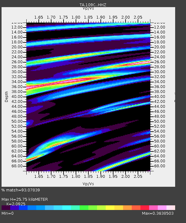
| Estimated Moho Depth: |
25.75 km |
| Estimated Crust Vp/Vs: |
2.09 |
| Assumed Crust Vp: |
6.264 km/s |
| Estimated Crust Vs: |
2.993 km/s |
| Estimated Crust Poisson's Ratio: |
0.35 |
|
| Radial Match: |
93.07839 % |
| Radial Bump: |
183 |
| Transverse Match: |
76.22974 % |
| Transverse Bump: |
400 |
| SOD ConfigId: |
13570011 |
| Insert Time: |
2019-04-29 15:04:27.869 +0000 |
| GWidth: |
2.5 |
| Max Bumps: |
400 |
| Tol: |
0.001 |
|

Signal To Noise
| Channel | StoN | STA | LTA |
| TA:109C: :HHZ:20180123T09:37:36.768003Z | 14.173928 | 1.6404372E-5 | 1.1573625E-6 |
| TA:109C: :HHN:20180123T09:37:36.768003Z | 17.526493 | 9.550621E-6 | 5.449248E-7 |
| TA:109C: :HHE:20180123T09:37:36.768003Z | 16.815346 | 6.867444E-6 | 4.0840337E-7 |
| Arrivals |
| Ps | 4.8 SECOND |
| PpPs | 12 SECOND |
| PsPs/PpSs | 17 SECOND |


