You are here: Home > Network List > TA - USArray Transportable Network (new EarthScope stations) Stations List
> Station 121A Cookes Peak, Deming, NM, USA > Earthquake Result Viewer
121A Cookes Peak, Deming, NM, USA - Earthquake Result Viewer
| Earthquake location: |
Gulf Of Alaska |
| Earthquake latitude/longitude: |
56.0/-149.1 |
| Earthquake time(UTC): |
2018/01/23 (023) 09:31:42 GMT |
| Earthquake Depth: |
25 km |
| Earthquake Magnitude: |
7.9 Mww |
| Earthquake Catalog/Contributor: |
NEIC PDE/us |
|
| Network: |
TA USArray Transportable Network (new EarthScope stations) |
| Station: |
121A Cookes Peak, Deming, NM, USA |
| Lat/Lon: |
32.53 N/107.79 W |
| Elevation: |
1652 m |
|
| Distance: |
36.9 deg |
| Az: |
111.99 deg |
| Baz: |
321.981 deg |
| Ray Param: |
0.07636351 |
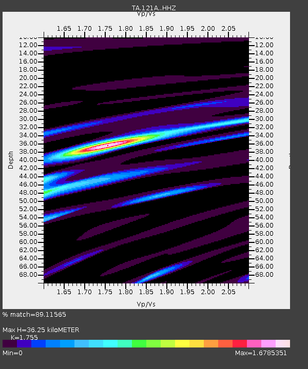
| Estimated Moho Depth: |
36.25 km |
| Estimated Crust Vp/Vs: |
1.75 |
| Assumed Crust Vp: |
6.502 km/s |
| Estimated Crust Vs: |
3.705 km/s |
| Estimated Crust Poisson's Ratio: |
0.26 |
|
| Radial Match: |
89.11565 % |
| Radial Bump: |
262 |
| Transverse Match: |
72.54957 % |
| Transverse Bump: |
400 |
| SOD ConfigId: |
13570011 |
| Insert Time: |
2019-04-29 15:04:29.269 +0000 |
| GWidth: |
2.5 |
| Max Bumps: |
400 |
| Tol: |
0.001 |
|
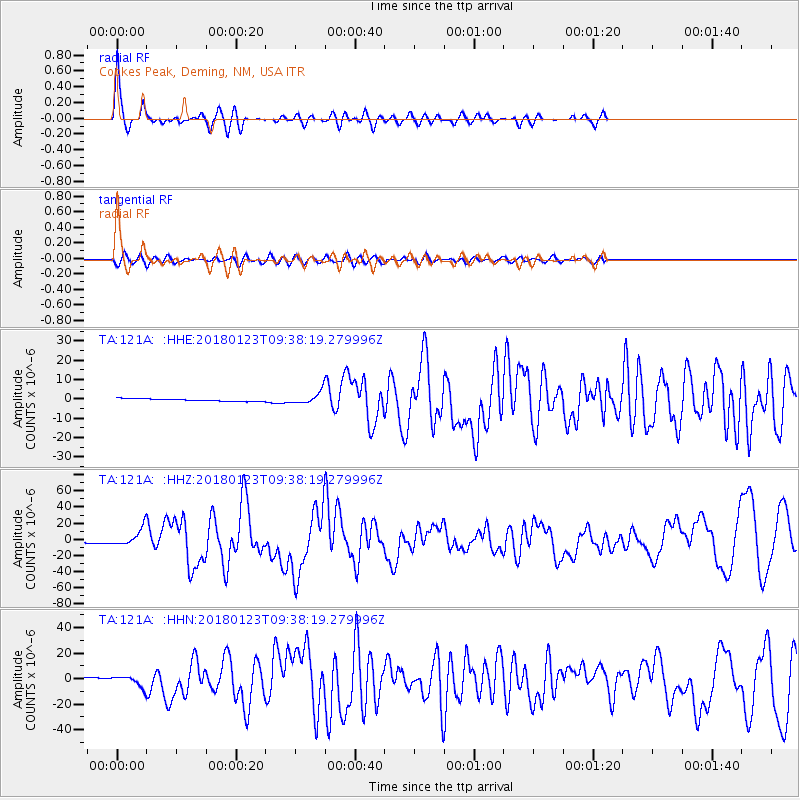
Signal To Noise
| Channel | StoN | STA | LTA |
| TA:121A: :HHZ:20180123T09:38:19.279996Z | 7.3176007 | 1.011069E-5 | 1.3816947E-6 |
| TA:121A: :HHN:20180123T09:38:19.279996Z | 4.4642663 | 3.9782603E-6 | 8.911342E-7 |
| TA:121A: :HHE:20180123T09:38:19.279996Z | 4.4158096 | 2.922723E-6 | 6.6187704E-7 |
| Arrivals |
| Ps | 4.5 SECOND |
| PpPs | 14 SECOND |
| PsPs/PpSs | 19 SECOND |


