You are here: Home > Network List > TA - USArray Transportable Network (new EarthScope stations) Stations List
> Station O20A White River City, CO, USA > Earthquake Result Viewer
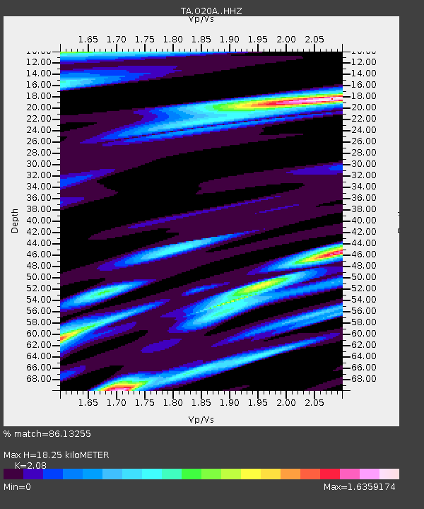
O20A White River City, CO, USA - Earthquake Result Viewer
| Earthquake location: |
Gulf Of Alaska |
| Earthquake latitude/longitude: |
56.0/-149.1 |
| Earthquake time(UTC): |
2018/01/23 (023) 09:31:42 GMT |
| Earthquake Depth: |
25 km |
| Earthquake Magnitude: |
7.9 Mww |
| Earthquake Catalog/Contributor: |
NEIC PDE/us |
|
| Network: |
TA USArray Transportable Network (new EarthScope stations) |
| Station: |
O20A White River City, CO, USA |
| Lat/Lon: |
40.13 N/108.24 W |
| Elevation: |
1915 m |
|
| Distance: |
31.0 deg |
| Az: |
103.452 deg |
| Baz: |
314.618 deg |
| Ray Param: |
0.079158515 |
| Estimated Moho Depth: |
18.25 km |
| Estimated Crust Vp/Vs: |
2.08 |
| Assumed Crust Vp: |
6.207 km/s |
| Estimated Crust Vs: |
2.984 km/s |
| Estimated Crust Poisson's Ratio: |
0.35 |
|
| Radial Match: |
86.13255 % |
| Radial Bump: |
400 |
| Transverse Match: |
80.8095 % |
| Transverse Bump: |
400 |
| SOD ConfigId: |
13570011 |
| Insert Time: |
2019-04-29 15:04:39.397 +0000 |
| GWidth: |
2.5 |
| Max Bumps: |
400 |
| Tol: |
0.001 |
|

Signal To Noise
| Channel | StoN | STA | LTA |
| TA:O20A: :HHZ:20180123T09:37:28.029996Z | 13.727122 | 1.2567894E-5 | 9.1555205E-7 |
| TA:O20A: :HHN:20180123T09:37:28.029996Z | 10.003526 | 4.8707957E-6 | 4.869079E-7 |
| TA:O20A: :HHE:20180123T09:37:28.029996Z | 8.710183 | 4.946936E-6 | 5.679486E-7 |
| Arrivals |
| Ps | 3.4 SECOND |
| PpPs | 8.5 SECOND |
| PsPs/PpSs | 12 SECOND |


