You are here: Home > Network List > TA - USArray Transportable Network (new EarthScope stations) Stations List
> Station T23A Casias Ranch, Antonito, CO, USA > Earthquake Result Viewer
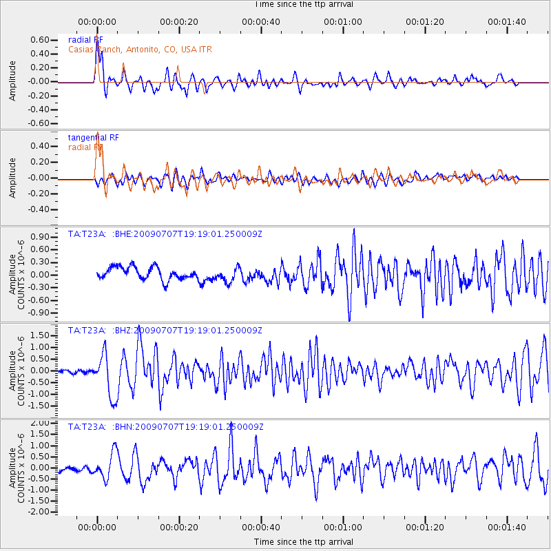
T23A Casias Ranch, Antonito, CO, USA - Earthquake Result Viewer
*The percent match for this event was below the threshold and hence no stack was calculated.
| Earthquake location: |
Baffin Bay |
| Earthquake latitude/longitude: |
75.4/-72.5 |
| Earthquake time(UTC): |
2009/07/07 (188) 19:11:46 GMT |
| Earthquake Depth: |
19 km |
| Earthquake Magnitude: |
5.9 MB, 5.7 MS, 6.1 MW, 6.0 MW |
| Earthquake Catalog/Contributor: |
WHDF/NEIC |
|
| Network: |
TA USArray Transportable Network (new EarthScope stations) |
| Station: |
T23A Casias Ranch, Antonito, CO, USA |
| Lat/Lon: |
37.04 N/106.04 W |
| Elevation: |
2429 m |
|
| Distance: |
41.4 deg |
| Az: |
221.974 deg |
| Baz: |
12.281 deg |
| Ray Param: |
$rayparam |
*The percent match for this event was below the threshold and hence was not used in the summary stack. |
|
| Radial Match: |
77.77186 % |
| Radial Bump: |
400 |
| Transverse Match: |
56.492233 % |
| Transverse Bump: |
400 |
| SOD ConfigId: |
2648 |
| Insert Time: |
2010-03-06 08:14:39.383 +0000 |
| GWidth: |
2.5 |
| Max Bumps: |
400 |
| Tol: |
0.001 |
|
Signal To Noise
| Channel | StoN | STA | LTA |
| TA:T23A: :BHZ:20090707T19:19:01.250009Z | 9.247177 | 9.476798E-7 | 1.0248314E-7 |
| TA:T23A: :BHN:20090707T19:19:01.250009Z | 5.3880877 | 6.0139865E-7 | 1.1161634E-7 |
| TA:T23A: :BHE:20090707T19:19:01.250009Z | 1.2341511 | 1.794077E-7 | 1.4536933E-7 |
| Arrivals |
| Ps | |
| PpPs | |
| PsPs/PpSs | |


