You are here: Home > Network List > TA - USArray Transportable Network (new EarthScope stations) Stations List
> Station P52A Corning, OH, USA > Earthquake Result Viewer
P52A Corning, OH, USA - Earthquake Result Viewer
| Earthquake location: |
Gulf Of Alaska |
| Earthquake latitude/longitude: |
56.0/-149.1 |
| Earthquake time(UTC): |
2018/01/23 (023) 09:31:42 GMT |
| Earthquake Depth: |
25 km |
| Earthquake Magnitude: |
7.9 Mww |
| Earthquake Catalog/Contributor: |
NEIC PDE/us |
|
| Network: |
TA USArray Transportable Network (new EarthScope stations) |
| Station: |
P52A Corning, OH, USA |
| Lat/Lon: |
39.63 N/82.13 W |
| Elevation: |
293 m |
|
| Distance: |
45.9 deg |
| Az: |
81.506 deg |
| Baz: |
314.059 deg |
| Ray Param: |
0.0709231 |
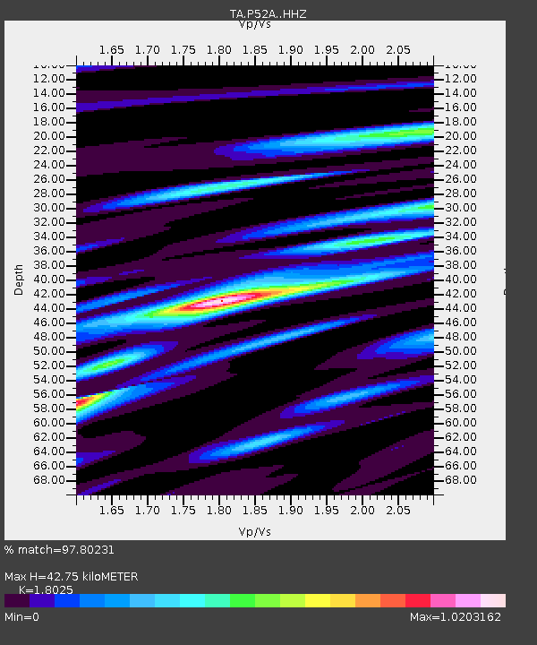
| Estimated Moho Depth: |
42.75 km |
| Estimated Crust Vp/Vs: |
1.80 |
| Assumed Crust Vp: |
6.232 km/s |
| Estimated Crust Vs: |
3.457 km/s |
| Estimated Crust Poisson's Ratio: |
0.28 |
|
| Radial Match: |
97.80231 % |
| Radial Bump: |
300 |
| Transverse Match: |
90.63879 % |
| Transverse Bump: |
400 |
| SOD ConfigId: |
13570011 |
| Insert Time: |
2019-04-29 15:04:41.506 +0000 |
| GWidth: |
2.5 |
| Max Bumps: |
400 |
| Tol: |
0.001 |
|

Signal To Noise
| Channel | StoN | STA | LTA |
| TA:P52A: :HHZ:20180123T09:39:32.749998Z | 8.105949 | 4.236549E-6 | 5.226469E-7 |
| TA:P52A: :HHN:20180123T09:39:32.749998Z | 3.8091128 | 1.6450111E-6 | 4.3186202E-7 |
| TA:P52A: :HHE:20180123T09:39:32.749998Z | 4.1298256 | 1.6933637E-6 | 4.1003278E-7 |
| Arrivals |
| Ps | 5.8 SECOND |
| PpPs | 18 SECOND |
| PsPs/PpSs | 24 SECOND |


