You are here: Home > Network List > TA - USArray Transportable Network (new EarthScope stations) Stations List
> Station Y22D IRIS PASSCAL Instrument Center, Socorro, NM, USA > Earthquake Result Viewer
Y22D IRIS PASSCAL Instrument Center, Socorro, NM, USA - Earthquake Result Viewer
| Earthquake location: |
Gulf Of Alaska |
| Earthquake latitude/longitude: |
56.0/-149.1 |
| Earthquake time(UTC): |
2018/01/23 (023) 09:31:42 GMT |
| Earthquake Depth: |
25 km |
| Earthquake Magnitude: |
7.9 Mww |
| Earthquake Catalog/Contributor: |
NEIC PDE/us |
|
| Network: |
TA USArray Transportable Network (new EarthScope stations) |
| Station: |
Y22D IRIS PASSCAL Instrument Center, Socorro, NM, USA |
| Lat/Lon: |
34.08 N/106.92 W |
| Elevation: |
1436 m |
|
| Distance: |
36.2 deg |
| Az: |
109.416 deg |
| Baz: |
320.386 deg |
| Ray Param: |
0.076772995 |
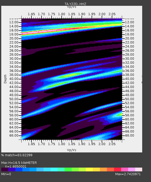
| Estimated Moho Depth: |
16.5 km |
| Estimated Crust Vp/Vs: |
1.69 |
| Assumed Crust Vp: |
6.502 km/s |
| Estimated Crust Vs: |
3.858 km/s |
| Estimated Crust Poisson's Ratio: |
0.23 |
|
| Radial Match: |
83.82299 % |
| Radial Bump: |
332 |
| Transverse Match: |
74.76696 % |
| Transverse Bump: |
400 |
| SOD ConfigId: |
13570011 |
| Insert Time: |
2019-04-29 15:04:48.585 +0000 |
| GWidth: |
2.5 |
| Max Bumps: |
400 |
| Tol: |
0.001 |
|

Signal To Noise
| Channel | StoN | STA | LTA |
| TA:Y22D: :HHZ:20180123T09:38:12.95001Z | 9.88631 | 9.146293E-6 | 9.2514733E-7 |
| TA:Y22D: :HHN:20180123T09:38:12.95001Z | 3.2303493 | 3.5315063E-6 | 1.0932274E-6 |
| TA:Y22D: :HHE:20180123T09:38:12.95001Z | 3.502187 | 2.5789877E-6 | 7.363935E-7 |
| Arrivals |
| Ps | 1.9 SECOND |
| PpPs | 6.3 SECOND |
| PsPs/PpSs | 8.2 SECOND |


