You are here: Home > Network List > WC - Curacao Seismic Network Stations List
> Station HATO Hato, Curacao > Earthquake Result Viewer
HATO Hato, Curacao - Earthquake Result Viewer
| Earthquake location: |
Gulf Of Alaska |
| Earthquake latitude/longitude: |
56.0/-149.1 |
| Earthquake time(UTC): |
2018/01/23 (023) 09:31:42 GMT |
| Earthquake Depth: |
25 km |
| Earthquake Magnitude: |
7.9 Mww |
| Earthquake Catalog/Contributor: |
NEIC PDE/us |
|
| Network: |
WC Curacao Seismic Network |
| Station: |
HATO Hato, Curacao |
| Lat/Lon: |
12.18 N/68.96 W |
| Elevation: |
40 m |
|
| Distance: |
74.5 deg |
| Az: |
91.268 deg |
| Baz: |
324.99 deg |
| Ray Param: |
0.052280463 |
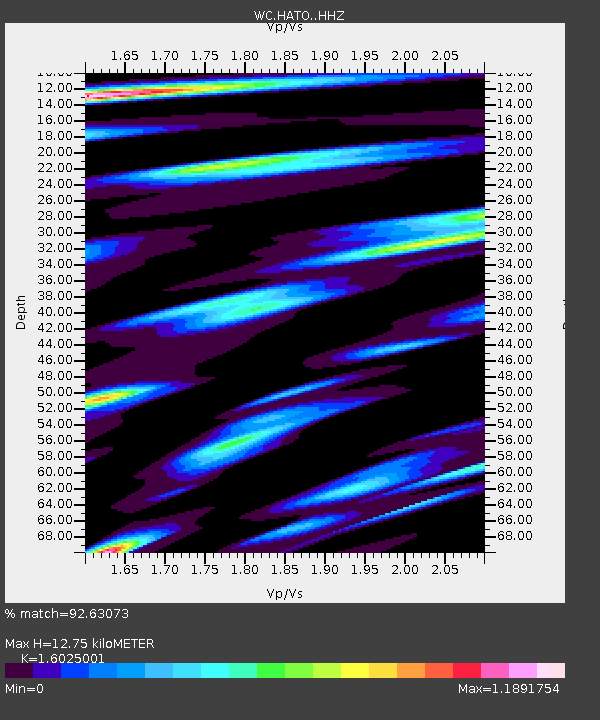
| Estimated Moho Depth: |
12.75 km |
| Estimated Crust Vp/Vs: |
1.60 |
| Assumed Crust Vp: |
5.88 km/s |
| Estimated Crust Vs: |
3.67 km/s |
| Estimated Crust Poisson's Ratio: |
0.18 |
|
| Radial Match: |
92.63073 % |
| Radial Bump: |
396 |
| Transverse Match: |
88.72253 % |
| Transverse Bump: |
400 |
| SOD ConfigId: |
13570011 |
| Insert Time: |
2019-04-29 15:05:30.942 +0000 |
| GWidth: |
2.5 |
| Max Bumps: |
400 |
| Tol: |
0.001 |
|
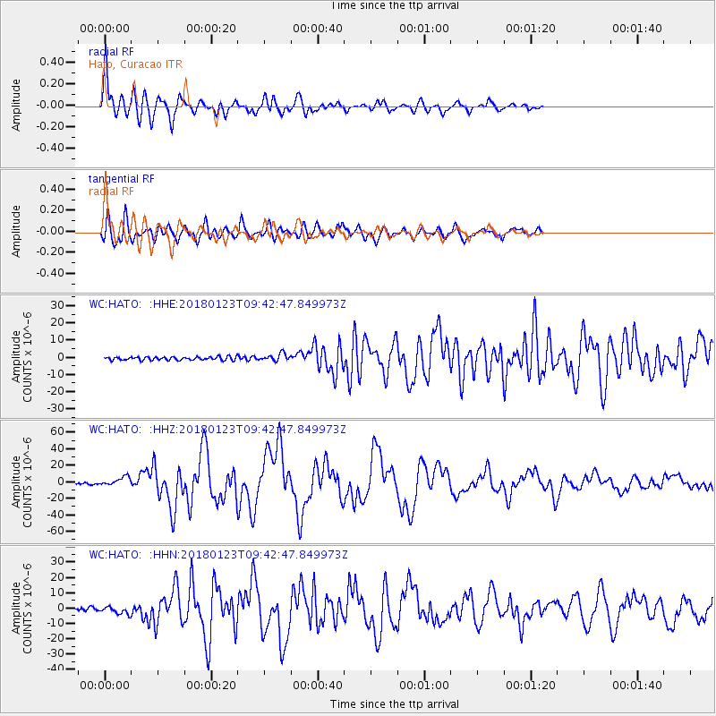
Signal To Noise
| Channel | StoN | STA | LTA |
| WC:HATO: :HHZ:20180123T09:42:47.849973Z | 5.664887 | 5.6079275E-6 | 9.899452E-7 |
| WC:HATO: :HHN:20180123T09:42:47.849973Z | 2.0680187 | 2.371443E-6 | 1.1467222E-6 |
| WC:HATO: :HHE:20180123T09:42:47.849973Z | 2.2895095 | 2.1669666E-6 | 9.4647635E-7 |
| Arrivals |
| Ps | 1.3 SECOND |
| PpPs | 5.5 SECOND |
| PsPs/PpSs | 6.8 SECOND |


