You are here: Home > Network List > XU16 - USGS NEHRP Proposal 2016-2018 - Greeley, CO Stations List
> Station GRCO Chill station, CO, USA > Earthquake Result Viewer
GRCO Chill station, CO, USA - Earthquake Result Viewer
| Earthquake location: |
Gulf Of Alaska |
| Earthquake latitude/longitude: |
56.0/-149.1 |
| Earthquake time(UTC): |
2018/01/23 (023) 09:31:42 GMT |
| Earthquake Depth: |
25 km |
| Earthquake Magnitude: |
7.9 Mww |
| Earthquake Catalog/Contributor: |
NEIC PDE/us |
|
| Network: |
XU USGS NEHRP Proposal 2016-2018 - Greeley, CO |
| Station: |
GRCO Chill station, CO, USA |
| Lat/Lon: |
40.45 N/104.64 W |
| Elevation: |
1427 m |
|
| Distance: |
32.8 deg |
| Az: |
99.402 deg |
| Baz: |
313.501 deg |
| Ray Param: |
0.078471065 |
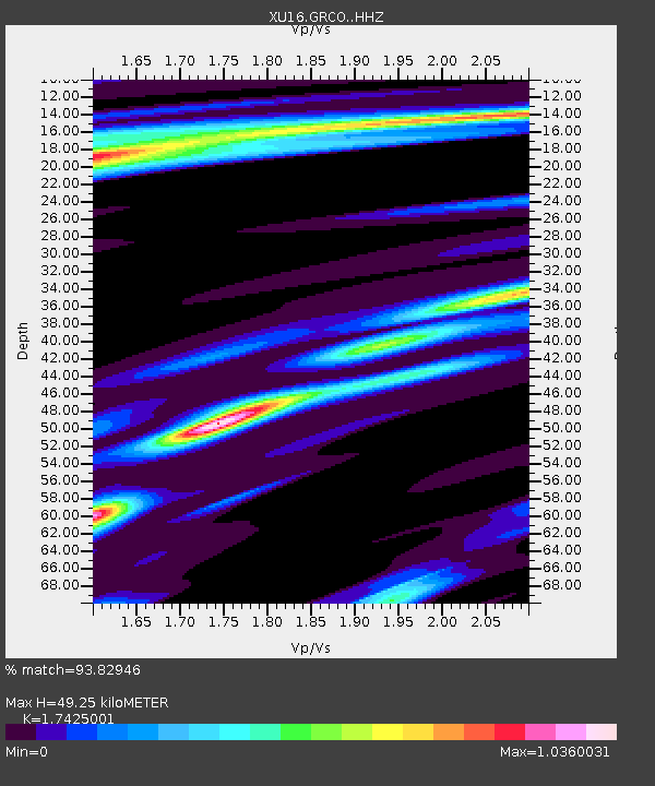
| Estimated Moho Depth: |
49.25 km |
| Estimated Crust Vp/Vs: |
1.74 |
| Assumed Crust Vp: |
6.306 km/s |
| Estimated Crust Vs: |
3.619 km/s |
| Estimated Crust Poisson's Ratio: |
0.25 |
|
| Radial Match: |
93.82946 % |
| Radial Bump: |
262 |
| Transverse Match: |
80.63209 % |
| Transverse Bump: |
400 |
| SOD ConfigId: |
13570011 |
| Insert Time: |
2019-04-29 15:05:50.722 +0000 |
| GWidth: |
2.5 |
| Max Bumps: |
400 |
| Tol: |
0.001 |
|

Signal To Noise
| Channel | StoN | STA | LTA |
| XU:GRCO: :HHZ:20180123T09:37:43.484006Z | 12.396393 | 8.200094E-6 | 6.6149033E-7 |
| XU:GRCO: :HH1:20180123T09:37:43.484006Z | 5.4240894 | 3.056758E-6 | 5.6355225E-7 |
| XU:GRCO: :HH2:20180123T09:37:43.484006Z | 4.229814 | 3.4345712E-6 | 8.11991E-7 |
| Arrivals |
| Ps | 6.3 SECOND |
| PpPs | 20 SECOND |
| PsPs/PpSs | 26 SECOND |


