You are here: Home > Network List > YX16 - Raton Basin UNM Broadband Network Stations List
> Station UNM6 NE Corner of CO Stations > Earthquake Result Viewer
UNM6 NE Corner of CO Stations - Earthquake Result Viewer
| Earthquake location: |
Gulf Of Alaska |
| Earthquake latitude/longitude: |
56.0/-149.1 |
| Earthquake time(UTC): |
2018/01/23 (023) 09:31:42 GMT |
| Earthquake Depth: |
25 km |
| Earthquake Magnitude: |
7.9 Mww |
| Earthquake Catalog/Contributor: |
NEIC PDE/us |
|
| Network: |
YX Raton Basin UNM Broadband Network |
| Station: |
UNM6 NE Corner of CO Stations |
| Lat/Lon: |
37.35 N/104.72 W |
| Elevation: |
2084 m |
|
| Distance: |
34.9 deg |
| Az: |
103.4 deg |
| Baz: |
316.768 deg |
| Ray Param: |
0.07744782 |
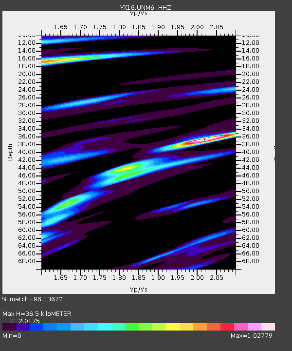
| Estimated Moho Depth: |
36.5 km |
| Estimated Crust Vp/Vs: |
2.02 |
| Assumed Crust Vp: |
6.316 km/s |
| Estimated Crust Vs: |
3.13 km/s |
| Estimated Crust Poisson's Ratio: |
0.34 |
|
| Radial Match: |
96.13672 % |
| Radial Bump: |
287 |
| Transverse Match: |
90.26199 % |
| Transverse Bump: |
400 |
| SOD ConfigId: |
13570011 |
| Insert Time: |
2019-04-29 15:06:01.165 +0000 |
| GWidth: |
2.5 |
| Max Bumps: |
400 |
| Tol: |
0.001 |
|

Signal To Noise
| Channel | StoN | STA | LTA |
| YX:UNM6: :HHZ:20180123T09:38:02.070005Z | 13.074193 | 9.242906E-6 | 7.069581E-7 |
| YX:UNM6: :HHN:20180123T09:38:02.070005Z | 7.783834 | 2.6708265E-6 | 3.431248E-7 |
| YX:UNM6: :HHE:20180123T09:38:02.070005Z | 7.745421 | 4.172576E-6 | 5.387152E-7 |
| Arrivals |
| Ps | 6.3 SECOND |
| PpPs | 16 SECOND |
| PsPs/PpSs | 23 SECOND |


