You are here: Home > Network List > TA - USArray Transportable Network (new EarthScope stations) Stations List
> Station S25A Robets Cordova Ranch, Walsenberg, CO, USA > Earthquake Result Viewer
S25A Robets Cordova Ranch, Walsenberg, CO, USA - Earthquake Result Viewer

| Earthquake location: |
Kuril Islands |
| Earthquake latitude/longitude: |
51.0/157.6 |
| Earthquake time(UTC): |
2008/07/24 (206) 01:43:16 GMT |
| Earthquake Depth: |
27 km |
| Earthquake Magnitude: |
6.0 MB, 6.0 MS, 6.2 MW, 6.2 MW |
| Earthquake Catalog/Contributor: |
WHDF/NEIC |
|
| Network: |
TA USArray Transportable Network (new EarthScope stations) |
| Station: |
S25A Robets Cordova Ranch, Walsenberg, CO, USA |
| Lat/Lon: |
37.66 N/104.43 W |
| Elevation: |
1821 m |
|
| Distance: |
66.3 deg |
| Az: |
59.116 deg |
| Baz: |
316.861 deg |
| Ray Param: |
0.05765729 |
| Estimated Moho Depth: |
52.5 km |
| Estimated Crust Vp/Vs: |
1.73 |
| Assumed Crust Vp: |
6.316 km/s |
| Estimated Crust Vs: |
3.656 km/s |
| Estimated Crust Poisson's Ratio: |
0.25 |
|
| Radial Match: |
82.40789 % |
| Radial Bump: |
400 |
| Transverse Match: |
77.238106 % |
| Transverse Bump: |
400 |
| SOD ConfigId: |
2504 |
| Insert Time: |
2010-03-06 08:15:23.600 +0000 |
| GWidth: |
2.5 |
| Max Bumps: |
400 |
| Tol: |
0.001 |
|
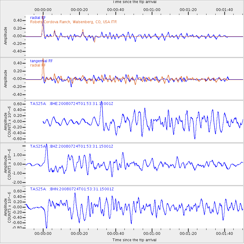
Signal To Noise
| Channel | StoN | STA | LTA |
| TA:S25A: :BHZ:20080724T01:53:31.15001Z | 15.243749 | 9.263989E-7 | 6.077238E-8 |
| TA:S25A: :BHN:20080724T01:53:31.15001Z | 4.665154 | 3.2328634E-7 | 6.92981E-8 |
| TA:S25A: :BHE:20080724T01:53:31.15001Z | 4.2371535 | 2.9629555E-7 | 6.992797E-8 |
| Arrivals |
| Ps | 6.3 SECOND |
| PpPs | 22 SECOND |
| PsPs/PpSs | 28 SECOND |


