You are here: Home > Network List > TA - USArray Transportable Network (new EarthScope stations) Stations List
> Station S25A Robets Cordova Ranch, Walsenberg, CO, USA > Earthquake Result Viewer
S25A Robets Cordova Ranch, Walsenberg, CO, USA - Earthquake Result Viewer
| Earthquake location: |
Virgin Islands |
| Earthquake latitude/longitude: |
19.2/-64.8 |
| Earthquake time(UTC): |
2008/10/11 (285) 10:40:14 GMT |
| Earthquake Depth: |
23 km |
| Earthquake Magnitude: |
6.1 MB, 5.9 MS, 6.1 MW, 6.0 MW |
| Earthquake Catalog/Contributor: |
WHDF/NEIC |
|
| Network: |
TA USArray Transportable Network (new EarthScope stations) |
| Station: |
S25A Robets Cordova Ranch, Walsenberg, CO, USA |
| Lat/Lon: |
37.66 N/104.43 W |
| Elevation: |
1821 m |
|
| Distance: |
39.1 deg |
| Az: |
306.593 deg |
| Baz: |
106.998 deg |
| Ray Param: |
0.07517028 |
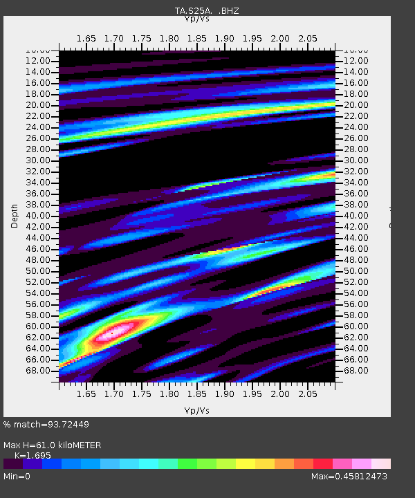
| Estimated Moho Depth: |
61.0 km |
| Estimated Crust Vp/Vs: |
1.70 |
| Assumed Crust Vp: |
6.316 km/s |
| Estimated Crust Vs: |
3.726 km/s |
| Estimated Crust Poisson's Ratio: |
0.23 |
|
| Radial Match: |
93.72449 % |
| Radial Bump: |
266 |
| Transverse Match: |
76.68858 % |
| Transverse Bump: |
400 |
| SOD ConfigId: |
2556 |
| Insert Time: |
2010-03-06 08:15:37.194 +0000 |
| GWidth: |
2.5 |
| Max Bumps: |
400 |
| Tol: |
0.001 |
|

Signal To Noise
| Channel | StoN | STA | LTA |
| TA:S25A: :BHZ:20081011T10:47:08.398989Z | 7.2447963 | 1.6679726E-6 | 2.3023044E-7 |
| TA:S25A: :BHN:20081011T10:47:08.398989Z | 1.9499604 | 4.939584E-7 | 2.5331715E-7 |
| TA:S25A: :BHE:20081011T10:47:08.398989Z | 3.8531332 | 1.1329004E-6 | 2.9402054E-7 |
| Arrivals |
| Ps | 7.2 SECOND |
| PpPs | 24 SECOND |
| PsPs/PpSs | 31 SECOND |


