You are here: Home > Network List > TA - USArray Transportable Network (new EarthScope stations) Stations List
> Station S25A Robets Cordova Ranch, Walsenberg, CO, USA > Earthquake Result Viewer
S25A Robets Cordova Ranch, Walsenberg, CO, USA - Earthquake Result Viewer
| Earthquake location: |
Near Coast Of Venezuela |
| Earthquake latitude/longitude: |
10.7/-67.9 |
| Earthquake time(UTC): |
2009/09/12 (255) 20:06:24 GMT |
| Earthquake Depth: |
10 km |
| Earthquake Magnitude: |
6.3 MB, 6.4 MS, 6.3 MW, 6.3 MW |
| Earthquake Catalog/Contributor: |
WHDF/NEIC |
|
| Network: |
TA USArray Transportable Network (new EarthScope stations) |
| Station: |
S25A Robets Cordova Ranch, Walsenberg, CO, USA |
| Lat/Lon: |
37.66 N/104.43 W |
| Elevation: |
1821 m |
|
| Distance: |
42.3 deg |
| Az: |
315.482 deg |
| Baz: |
119.74 deg |
| Ray Param: |
0.073231146 |
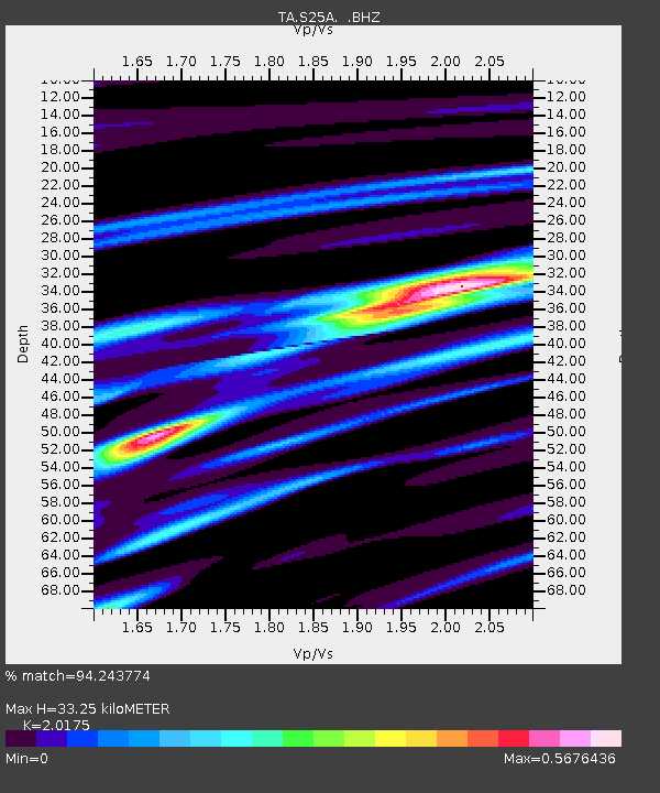
| Estimated Moho Depth: |
33.25 km |
| Estimated Crust Vp/Vs: |
2.02 |
| Assumed Crust Vp: |
6.316 km/s |
| Estimated Crust Vs: |
3.13 km/s |
| Estimated Crust Poisson's Ratio: |
0.34 |
|
| Radial Match: |
94.243774 % |
| Radial Bump: |
197 |
| Transverse Match: |
68.49775 % |
| Transverse Bump: |
400 |
| SOD ConfigId: |
2622 |
| Insert Time: |
2010-03-06 08:16:12.585 +0000 |
| GWidth: |
2.5 |
| Max Bumps: |
400 |
| Tol: |
0.001 |
|
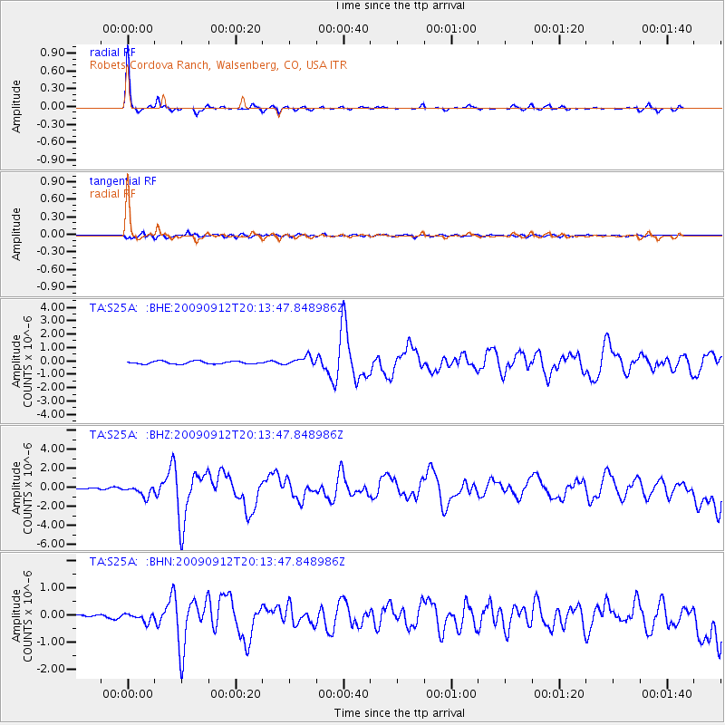
Signal To Noise
| Channel | StoN | STA | LTA |
| TA:S25A: :BHZ:20090912T20:13:47.848986Z | 9.064473 | 5.900406E-7 | 6.509375E-8 |
| TA:S25A: :BHN:20090912T20:13:47.848986Z | 2.1159751 | 1.49546E-7 | 7.0674744E-8 |
| TA:S25A: :BHE:20090912T20:13:47.848986Z | 3.3246946 | 3.4022491E-7 | 1.0233268E-7 |
| Arrivals |
| Ps | 5.7 SECOND |
| PpPs | 15 SECOND |
| PsPs/PpSs | 21 SECOND |


