You are here: Home > Network List > TA - USArray Transportable Network (new EarthScope stations) Stations List
> Station S25A Robets Cordova Ranch, Walsenberg, CO, USA > Earthquake Result Viewer
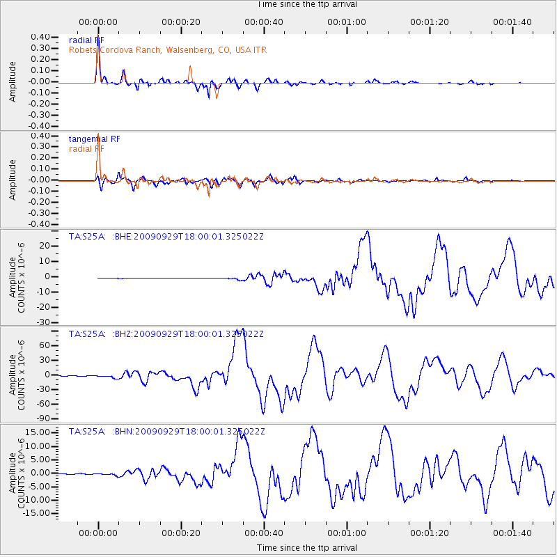
S25A Robets Cordova Ranch, Walsenberg, CO, USA - Earthquake Result Viewer
| Earthquake location: |
Samoa Islands Region |
| Earthquake latitude/longitude: |
-15.5/-172.1 |
| Earthquake time(UTC): |
2009/09/29 (272) 17:48:10 GMT |
| Earthquake Depth: |
18 km |
| Earthquake Magnitude: |
7.1 MB, 8.1 MS, 8.1 MW, 8.0 MW |
| Earthquake Catalog/Contributor: |
WHDF/NEIC |
|
| Network: |
TA USArray Transportable Network (new EarthScope stations) |
| Station: |
S25A Robets Cordova Ranch, Walsenberg, CO, USA |
| Lat/Lon: |
37.66 N/104.43 W |
| Elevation: |
1821 m |
|
| Distance: |
82.6 deg |
| Az: |
47.755 deg |
| Baz: |
244.071 deg |
| Ray Param: |
0.046783842 |
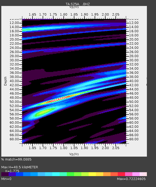
| Estimated Moho Depth: |
48.5 km |
| Estimated Crust Vp/Vs: |
1.77 |
| Assumed Crust Vp: |
6.316 km/s |
| Estimated Crust Vs: |
3.558 km/s |
| Estimated Crust Poisson's Ratio: |
0.27 |
|
| Radial Match: |
99.0885 % |
| Radial Bump: |
295 |
| Transverse Match: |
95.26229 % |
| Transverse Bump: |
400 |
| SOD ConfigId: |
2622 |
| Insert Time: |
2010-03-06 08:16:14.194 +0000 |
| GWidth: |
2.5 |
| Max Bumps: |
400 |
| Tol: |
0.001 |
|
Signal To Noise
| Channel | StoN | STA | LTA |
| TA:S25A: :BHZ:20090929T18:00:01.325022Z | 16.017517 | 2.8545794E-6 | 1.782161E-7 |
| TA:S25A: :BHN:20090929T18:00:01.325022Z | 4.9146047 | 3.6381E-7 | 7.4026296E-8 |
| TA:S25A: :BHE:20090929T18:00:01.325022Z | 8.668919 | 7.035157E-7 | 8.115381E-8 |
| Arrivals |
| Ps | 6.1 SECOND |
| PpPs | 21 SECOND |
| PsPs/PpSs | 27 SECOND |


