You are here: Home > Network List > AZ - ANZA Regional Network Stations List
> Station FRD AZ.FRD > Earthquake Result Viewer
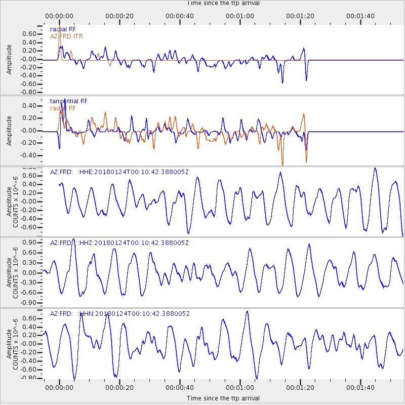
FRD AZ.FRD - Earthquake Result Viewer
*The percent match for this event was below the threshold and hence no stack was calculated.
| Earthquake location: |
Gulf Of Alaska |
| Earthquake latitude/longitude: |
56.5/-148.5 |
| Earthquake time(UTC): |
2018/01/24 (024) 00:04:48 GMT |
| Earthquake Depth: |
10 km |
| Earthquake Magnitude: |
5.5 Mww |
| Earthquake Catalog/Contributor: |
NEIC PDE/us |
|
| Network: |
AZ ANZA Regional Network |
| Station: |
FRD AZ.FRD |
| Lat/Lon: |
33.49 N/116.60 W |
| Elevation: |
1164 m |
|
| Distance: |
31.8 deg |
| Az: |
122.94 deg |
| Baz: |
326.191 deg |
| Ray Param: |
$rayparam |
*The percent match for this event was below the threshold and hence was not used in the summary stack. |
|
| Radial Match: |
60.036808 % |
| Radial Bump: |
400 |
| Transverse Match: |
85.02512 % |
| Transverse Bump: |
400 |
| SOD ConfigId: |
13570011 |
| Insert Time: |
2019-04-29 15:24:00.914 +0000 |
| GWidth: |
2.5 |
| Max Bumps: |
400 |
| Tol: |
0.001 |
|
Signal To Noise
| Channel | StoN | STA | LTA |
| AZ:FRD: :HHZ:20180124T00:10:42.388005Z | 2.2853324 | 4.959324E-7 | 2.1700669E-7 |
| AZ:FRD: :HHN:20180124T00:10:42.388005Z | 1.0107855 | 3.85649E-7 | 3.8153397E-7 |
| AZ:FRD: :HHE:20180124T00:10:42.388005Z | 0.4691665 | 1.2112913E-7 | 2.5817943E-7 |
| Arrivals |
| Ps | |
| PpPs | |
| PsPs/PpSs | |


