You are here: Home > Network List > AZ - ANZA Regional Network Stations List
> Station SMER AZ.SMER > Earthquake Result Viewer
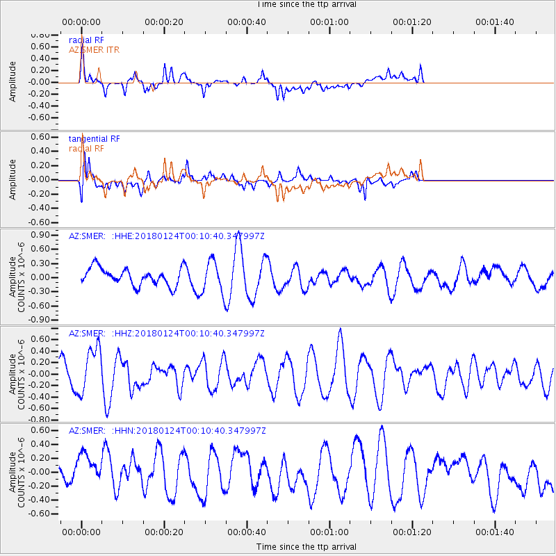
SMER AZ.SMER - Earthquake Result Viewer
*The percent match for this event was below the threshold and hence no stack was calculated.
| Earthquake location: |
Gulf Of Alaska |
| Earthquake latitude/longitude: |
56.5/-148.5 |
| Earthquake time(UTC): |
2018/01/24 (024) 00:04:48 GMT |
| Earthquake Depth: |
10 km |
| Earthquake Magnitude: |
5.5 Mww |
| Earthquake Catalog/Contributor: |
NEIC PDE/us |
|
| Network: |
AZ ANZA Regional Network |
| Station: |
SMER AZ.SMER |
| Lat/Lon: |
33.46 N/117.17 W |
| Elevation: |
355 m |
|
| Distance: |
31.5 deg |
| Az: |
123.733 deg |
| Baz: |
326.555 deg |
| Ray Param: |
$rayparam |
*The percent match for this event was below the threshold and hence was not used in the summary stack. |
|
| Radial Match: |
45.30952 % |
| Radial Bump: |
400 |
| Transverse Match: |
68.00854 % |
| Transverse Bump: |
400 |
| SOD ConfigId: |
13570011 |
| Insert Time: |
2019-04-29 15:24:03.031 +0000 |
| GWidth: |
2.5 |
| Max Bumps: |
400 |
| Tol: |
0.001 |
|
Signal To Noise
| Channel | StoN | STA | LTA |
| AZ:SMER: :HHZ:20180124T00:10:40.347997Z | 2.1929083 | 4.1011694E-7 | 1.8701965E-7 |
| AZ:SMER: :HHN:20180124T00:10:40.347997Z | 1.3167368 | 3.4860494E-7 | 2.6474913E-7 |
| AZ:SMER: :HHE:20180124T00:10:40.347997Z | 1.8560476 | 3.2830258E-7 | 1.7688262E-7 |
| Arrivals |
| Ps | |
| PpPs | |
| PsPs/PpSs | |


