You are here: Home > Network List > TA - USArray Transportable Network (new EarthScope stations) Stations List
> Station SFIN Lafayette, IN, USA > Earthquake Result Viewer
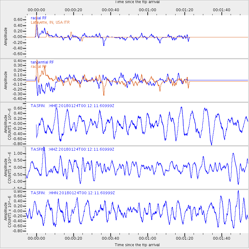
SFIN Lafayette, IN, USA - Earthquake Result Viewer
*The percent match for this event was below the threshold and hence no stack was calculated.
| Earthquake location: |
Gulf Of Alaska |
| Earthquake latitude/longitude: |
56.5/-148.5 |
| Earthquake time(UTC): |
2018/01/24 (024) 00:04:48 GMT |
| Earthquake Depth: |
10 km |
| Earthquake Magnitude: |
5.5 Mww |
| Earthquake Catalog/Contributor: |
NEIC PDE/us |
|
| Network: |
TA USArray Transportable Network (new EarthScope stations) |
| Station: |
SFIN Lafayette, IN, USA |
| Lat/Lon: |
40.38 N/87.10 W |
| Elevation: |
165 m |
|
| Distance: |
42.3 deg |
| Az: |
85.46 deg |
| Baz: |
313.699 deg |
| Ray Param: |
$rayparam |
*The percent match for this event was below the threshold and hence was not used in the summary stack. |
|
| Radial Match: |
47.07326 % |
| Radial Bump: |
400 |
| Transverse Match: |
72.57836 % |
| Transverse Bump: |
400 |
| SOD ConfigId: |
13570011 |
| Insert Time: |
2019-04-29 15:29:10.685 +0000 |
| GWidth: |
2.5 |
| Max Bumps: |
400 |
| Tol: |
0.001 |
|
Signal To Noise
| Channel | StoN | STA | LTA |
| TA:SFIN: :HHZ:20180124T00:12:11.60999Z | 1.9679834 | 6.522334E-7 | 3.314222E-7 |
| TA:SFIN: :HHN:20180124T00:12:11.60999Z | 1.1738156 | 2.9142734E-7 | 2.4827352E-7 |
| TA:SFIN: :HHE:20180124T00:12:11.60999Z | 0.75907844 | 2.3326436E-7 | 3.0729942E-7 |
| Arrivals |
| Ps | |
| PpPs | |
| PsPs/PpSs | |


