You are here: Home > Network List > TA - USArray Transportable Network (new EarthScope stations) Stations List
> Station TPFO Pinon Flats, CA, USA > Earthquake Result Viewer
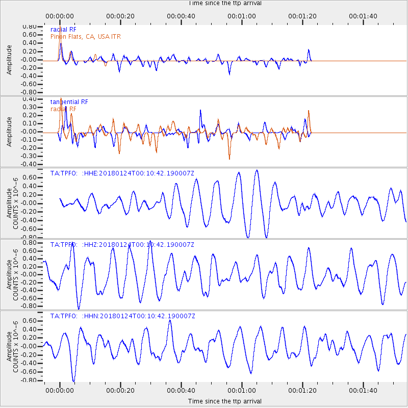
TPFO Pinon Flats, CA, USA - Earthquake Result Viewer
*The percent match for this event was below the threshold and hence no stack was calculated.
| Earthquake location: |
Gulf Of Alaska |
| Earthquake latitude/longitude: |
56.5/-148.5 |
| Earthquake time(UTC): |
2018/01/24 (024) 00:04:48 GMT |
| Earthquake Depth: |
10 km |
| Earthquake Magnitude: |
5.5 Mww |
| Earthquake Catalog/Contributor: |
NEIC PDE/us |
|
| Network: |
TA USArray Transportable Network (new EarthScope stations) |
| Station: |
TPFO Pinon Flats, CA, USA |
| Lat/Lon: |
33.61 N/116.45 W |
| Elevation: |
1275 m |
|
| Distance: |
31.7 deg |
| Az: |
122.627 deg |
| Baz: |
326.007 deg |
| Ray Param: |
$rayparam |
*The percent match for this event was below the threshold and hence was not used in the summary stack. |
|
| Radial Match: |
55.48522 % |
| Radial Bump: |
400 |
| Transverse Match: |
71.3976 % |
| Transverse Bump: |
337 |
| SOD ConfigId: |
13570011 |
| Insert Time: |
2019-04-29 15:29:11.527 +0000 |
| GWidth: |
2.5 |
| Max Bumps: |
400 |
| Tol: |
0.001 |
|
Signal To Noise
| Channel | StoN | STA | LTA |
| TA:TPFO: :HHZ:20180124T00:10:42.190007Z | 1.9468334 | 3.985923E-7 | 2.047388E-7 |
| TA:TPFO: :HHN:20180124T00:10:42.190007Z | 2.813853 | 3.674971E-7 | 1.3060281E-7 |
| TA:TPFO: :HHE:20180124T00:10:42.190007Z | 0.92188156 | 1.1396491E-7 | 1.2362207E-7 |
| Arrivals |
| Ps | |
| PpPs | |
| PsPs/PpSs | |


