You are here: Home > Network List > AV - Alaska Volcano Observatory Stations List
> Station SPCN Ckakachatna North Broadband, Mount Spurr, Alaska > Earthquake Result Viewer
SPCN Ckakachatna North Broadband, Mount Spurr, Alaska - Earthquake Result Viewer
| Earthquake location: |
Hokkaido, Japan Region |
| Earthquake latitude/longitude: |
41.1/142.3 |
| Earthquake time(UTC): |
2018/01/24 (024) 10:51:20 GMT |
| Earthquake Depth: |
40 km |
| Earthquake Magnitude: |
6.2 Mww |
| Earthquake Catalog/Contributor: |
NEIC PDE/us |
|
| Network: |
AV Alaska Volcano Observatory |
| Station: |
SPCN Ckakachatna North Broadband, Mount Spurr, Alaska |
| Lat/Lon: |
61.22 N/152.19 W |
| Elevation: |
735 m |
|
| Distance: |
43.5 deg |
| Az: |
39.733 deg |
| Baz: |
273.582 deg |
| Ray Param: |
0.07238816 |
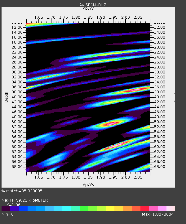
| Estimated Moho Depth: |
59.25 km |
| Estimated Crust Vp/Vs: |
1.96 |
| Assumed Crust Vp: |
6.566 km/s |
| Estimated Crust Vs: |
3.35 km/s |
| Estimated Crust Poisson's Ratio: |
0.32 |
|
| Radial Match: |
85.038895 % |
| Radial Bump: |
400 |
| Transverse Match: |
85.35212 % |
| Transverse Bump: |
400 |
| SOD ConfigId: |
13570011 |
| Insert Time: |
2019-04-29 15:32:04.967 +0000 |
| GWidth: |
2.5 |
| Max Bumps: |
400 |
| Tol: |
0.001 |
|
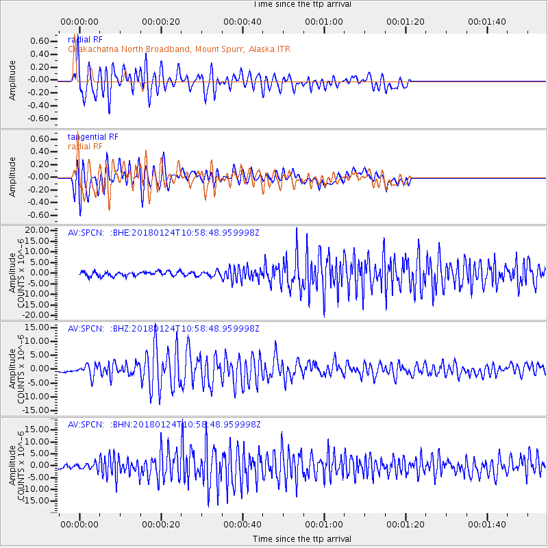
Signal To Noise
| Channel | StoN | STA | LTA |
| AV:SPCN: :BHZ:20180124T10:58:48.959998Z | 4.9059253 | 2.1424632E-6 | 4.367093E-7 |
| AV:SPCN: :BHN:20180124T10:58:48.959998Z | 1.5705955 | 1.3024902E-6 | 8.2929705E-7 |
| AV:SPCN: :BHE:20180124T10:58:48.959998Z | 1.4637842 | 1.4784802E-6 | 1.0100397E-6 |
| Arrivals |
| Ps | 9.2 SECOND |
| PpPs | 25 SECOND |
| PsPs/PpSs | 34 SECOND |


