You are here: Home > Network List > US - United States National Seismic Network Stations List
> Station DGMT Dagmar, Montana, USA > Earthquake Result Viewer
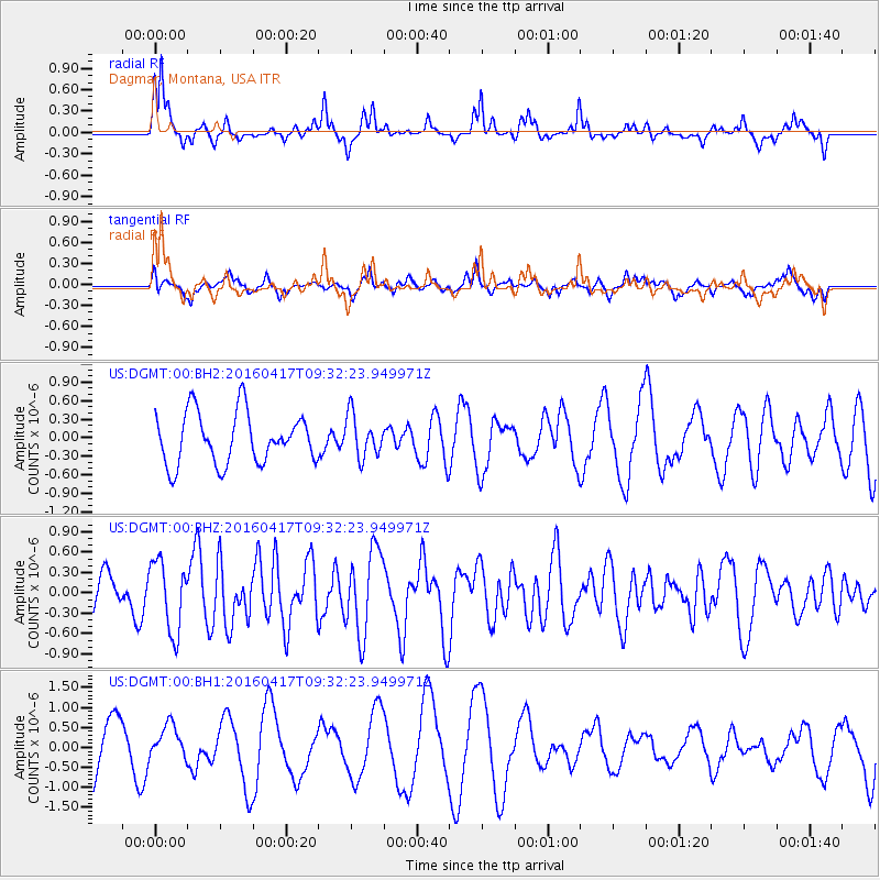
DGMT Dagmar, Montana, USA - Earthquake Result Viewer
*The percent match for this event was below the threshold and hence no stack was calculated.
| Earthquake location: |
Near Coast Of Ecuador |
| Earthquake latitude/longitude: |
-0.3/-80.7 |
| Earthquake time(UTC): |
2016/04/17 (108) 09:23:40 GMT |
| Earthquake Depth: |
10 km |
| Earthquake Magnitude: |
5.5 MB |
| Earthquake Catalog/Contributor: |
NEIC PDE/NEIC COMCAT |
|
| Network: |
US United States National Seismic Network |
| Station: |
DGMT Dagmar, Montana, USA |
| Lat/Lon: |
48.47 N/104.20 W |
| Elevation: |
0.0 m |
|
| Distance: |
52.6 deg |
| Az: |
340.508 deg |
| Baz: |
149.908 deg |
| Ray Param: |
$rayparam |
*The percent match for this event was below the threshold and hence was not used in the summary stack. |
|
| Radial Match: |
67.69652 % |
| Radial Bump: |
363 |
| Transverse Match: |
52.48543 % |
| Transverse Bump: |
395 |
| SOD ConfigId: |
1475611 |
| Insert Time: |
2016-05-01 09:29:49.384 +0000 |
| GWidth: |
2.5 |
| Max Bumps: |
400 |
| Tol: |
0.001 |
|
Signal To Noise
| Channel | StoN | STA | LTA |
| US:DGMT:00:BHZ:20160417T09:32:23.949971Z | 2.62949 | 5.161923E-7 | 1.963089E-7 |
| US:DGMT:00:BH1:20160417T09:32:23.949971Z | 0.41774738 | 4.0893656E-7 | 9.789087E-7 |
| US:DGMT:00:BH2:20160417T09:32:23.949971Z | 0.8243293 | 3.4056524E-7 | 4.1314223E-7 |
| Arrivals |
| Ps | |
| PpPs | |
| PsPs/PpSs | |


