You are here: Home > Network List > US - United States National Seismic Network Stations List
> Station GLMI Grayling, Michigan, USA > Earthquake Result Viewer
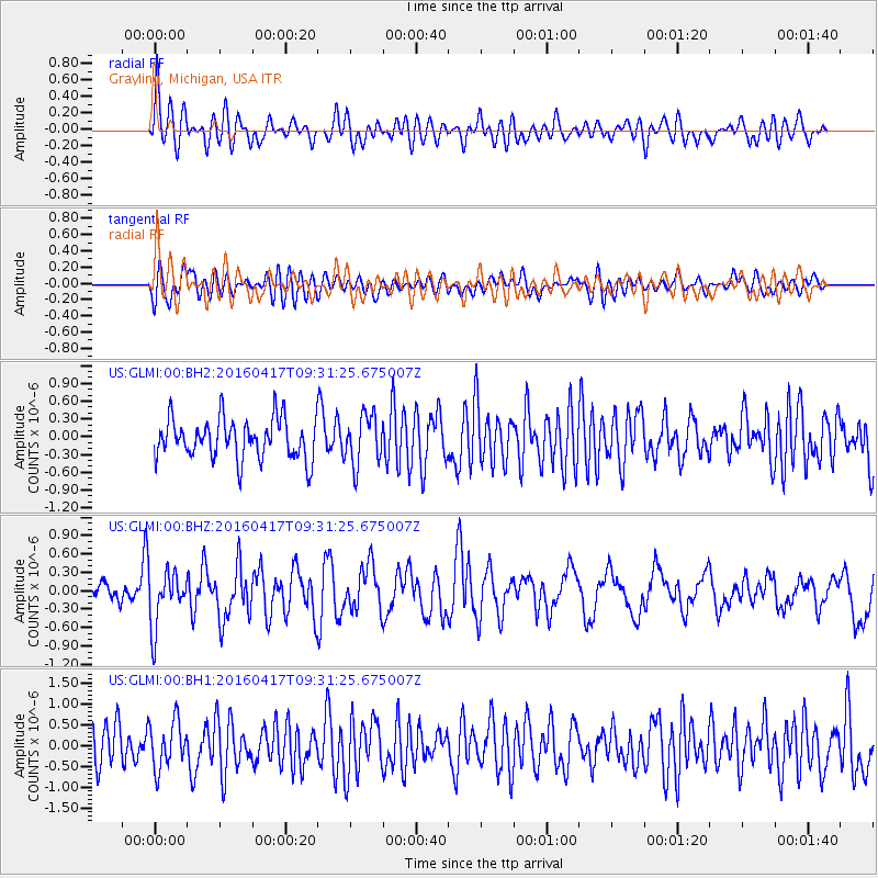
GLMI Grayling, Michigan, USA - Earthquake Result Viewer
*The percent match for this event was below the threshold and hence no stack was calculated.
| Earthquake location: |
Near Coast Of Ecuador |
| Earthquake latitude/longitude: |
-0.3/-80.7 |
| Earthquake time(UTC): |
2016/04/17 (108) 09:23:40 GMT |
| Earthquake Depth: |
10 km |
| Earthquake Magnitude: |
5.5 MB |
| Earthquake Catalog/Contributor: |
NEIC PDE/NEIC COMCAT |
|
| Network: |
US United States National Seismic Network |
| Station: |
GLMI Grayling, Michigan, USA |
| Lat/Lon: |
44.82 N/84.62 W |
| Elevation: |
387 m |
|
| Distance: |
45.0 deg |
| Az: |
356.075 deg |
| Baz: |
174.48 deg |
| Ray Param: |
$rayparam |
*The percent match for this event was below the threshold and hence was not used in the summary stack. |
|
| Radial Match: |
66.389015 % |
| Radial Bump: |
400 |
| Transverse Match: |
56.233925 % |
| Transverse Bump: |
400 |
| SOD ConfigId: |
1475611 |
| Insert Time: |
2016-05-01 09:30:05.104 +0000 |
| GWidth: |
2.5 |
| Max Bumps: |
400 |
| Tol: |
0.001 |
|
Signal To Noise
| Channel | StoN | STA | LTA |
| US:GLMI:00:BHZ:20160417T09:31:25.675007Z | 2.7789087 | 4.471653E-7 | 1.60914E-7 |
| US:GLMI:00:BH1:20160417T09:31:25.675007Z | 1.3941544 | 5.6273876E-7 | 4.036416E-7 |
| US:GLMI:00:BH2:20160417T09:31:25.675007Z | 1.2290851 | 4.1457713E-7 | 3.373055E-7 |
| Arrivals |
| Ps | |
| PpPs | |
| PsPs/PpSs | |


