You are here: Home > Network List > KZ - Kazakhstan Network Stations List
> Station MAKZ Makanchi, Kazakstan > Earthquake Result Viewer
MAKZ Makanchi, Kazakstan - Earthquake Result Viewer
| Earthquake location: |
Hokkaido, Japan Region |
| Earthquake latitude/longitude: |
41.1/142.3 |
| Earthquake time(UTC): |
2018/01/24 (024) 10:51:20 GMT |
| Earthquake Depth: |
40 km |
| Earthquake Magnitude: |
6.2 Mww |
| Earthquake Catalog/Contributor: |
NEIC PDE/us |
|
| Network: |
KZ Kazakhstan Network |
| Station: |
MAKZ Makanchi, Kazakstan |
| Lat/Lon: |
46.81 N/81.98 E |
| Elevation: |
600 m |
|
| Distance: |
42.9 deg |
| Az: |
298.664 deg |
| Baz: |
74.817 deg |
| Ray Param: |
0.07283372 |
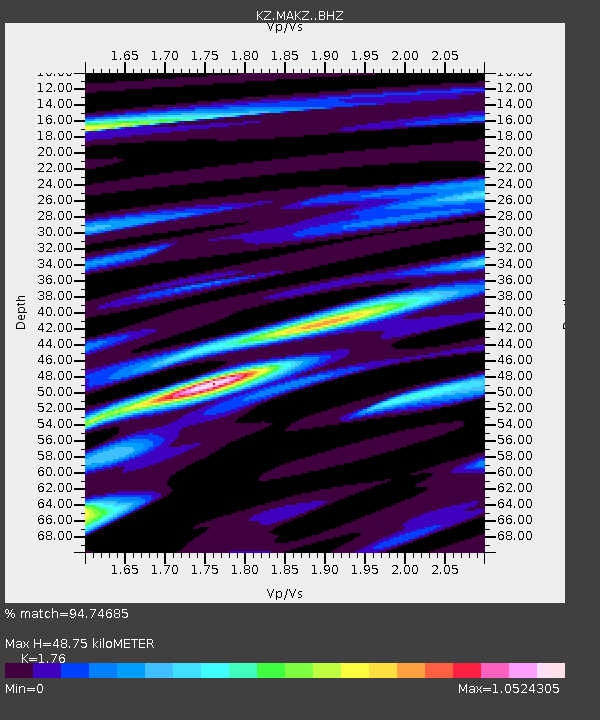
| Estimated Moho Depth: |
48.75 km |
| Estimated Crust Vp/Vs: |
1.76 |
| Assumed Crust Vp: |
6.571 km/s |
| Estimated Crust Vs: |
3.733 km/s |
| Estimated Crust Poisson's Ratio: |
0.26 |
|
| Radial Match: |
94.74685 % |
| Radial Bump: |
359 |
| Transverse Match: |
83.01939 % |
| Transverse Bump: |
400 |
| SOD ConfigId: |
13570011 |
| Insert Time: |
2019-04-29 15:35:36.242 +0000 |
| GWidth: |
2.5 |
| Max Bumps: |
400 |
| Tol: |
0.001 |
|

Signal To Noise
| Channel | StoN | STA | LTA |
| KZ:MAKZ: :BHZ:20180124T10:58:44.600012Z | 31.115526 | 4.064465E-6 | 1.3062498E-7 |
| KZ:MAKZ: :BHN:20180124T10:58:44.600012Z | 9.253247 | 9.623661E-7 | 1.04003064E-7 |
| KZ:MAKZ: :BHE:20180124T10:58:44.600012Z | 38.804058 | 2.0261762E-6 | 5.2215576E-8 |
| Arrivals |
| Ps | 6.1 SECOND |
| PpPs | 19 SECOND |
| PsPs/PpSs | 25 SECOND |


