You are here: Home > Network List > TA - USArray Transportable Network (new EarthScope stations) Stations List
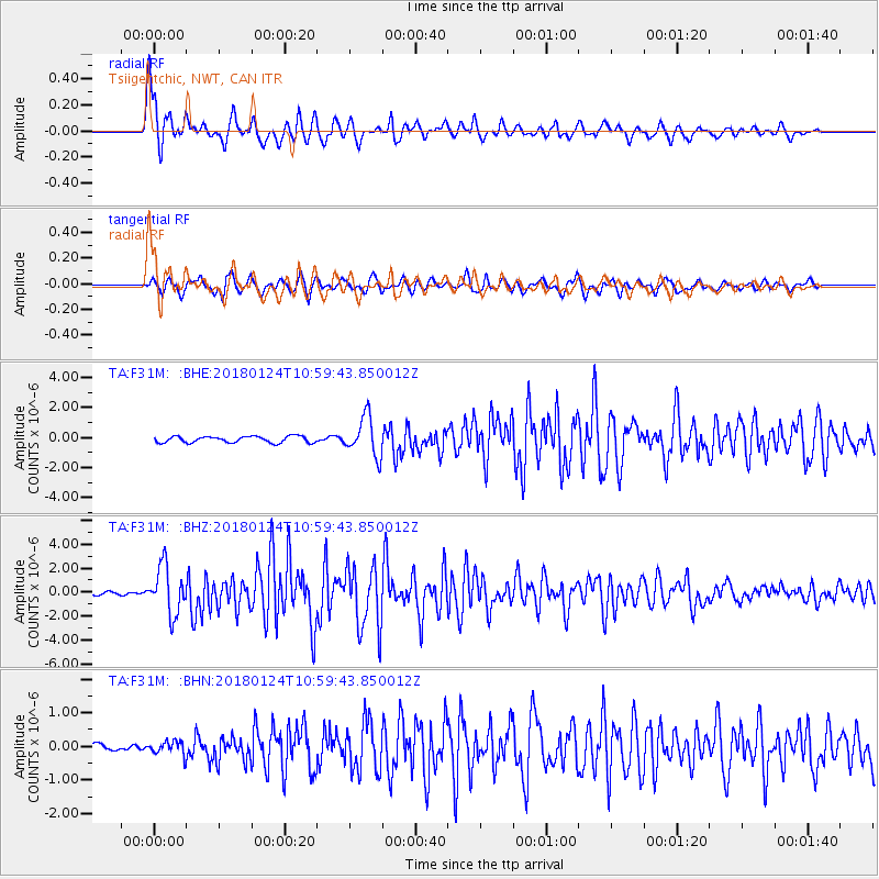
> Station F31M Tsiigehtchic, NWT, CAN > Earthquake Result Viewer
F31M Tsiigehtchic, NWT, CAN - Earthquake Result Viewer
| Earthquake location: |
Hokkaido, Japan Region |
| Earthquake latitude/longitude: |
41.1/142.3 |
| Earthquake time(UTC): |
2018/01/24 (024) 10:51:20 GMT |
| Earthquake Depth: |
40 km |
| Earthquake Magnitude: |
6.2 Mww |
| Earthquake Catalog/Contributor: |
NEIC PDE/us |
|
| Network: |
TA USArray Transportable Network (new EarthScope stations) |
| Station: |
F31M Tsiigehtchic, NWT, CAN |
| Lat/Lon: |
67.44 N/133.74 W |
| Elevation: |
56 m |
|
| Distance: |
50.6 deg |
| Az: |
29.784 deg |
| Baz: |
283.436 deg |
| Ray Param: |
0.06787441 |
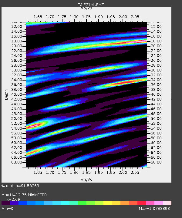
| Estimated Moho Depth: |
17.75 km |
| Estimated Crust Vp/Vs: |
2.09 |
| Assumed Crust Vp: |
6.171 km/s |
| Estimated Crust Vs: |
2.953 km/s |
| Estimated Crust Poisson's Ratio: |
0.35 |
|
| Radial Match: |
91.58369 % |
| Radial Bump: |
400 |
| Transverse Match: |
76.05086 % |
| Transverse Bump: |
400 |
| SOD ConfigId: |
13570011 |
| Insert Time: |
2019-04-29 15:40:17.062 +0000 |
| GWidth: |
2.5 |
| Max Bumps: |
400 |
| Tol: |
0.001 |
|
Signal To Noise
| Channel | StoN | STA | LTA |
| TA:F31M: :BHZ:20180124T10:59:43.850012Z | 11.563024 | 1.970703E-6 | 1.7043146E-7 |
| TA:F31M: :BHN:20180124T10:59:43.850012Z | 0.9616437 | 2.1318564E-7 | 2.2168881E-7 |
| TA:F31M: :BHE:20180124T10:59:43.850012Z | 6.359224 | 1.318662E-6 | 2.073621E-7 |
| Arrivals |
| Ps | 3.3 SECOND |
| PpPs | 8.5 SECOND |
| PsPs/PpSs | 12 SECOND |


