You are here: Home > Network List > TA - USArray Transportable Network (new EarthScope stations) Stations List
> Station H19K Roundabout Mountain, AK, USA > Earthquake Result Viewer
H19K Roundabout Mountain, AK, USA - Earthquake Result Viewer
| Earthquake location: |
Hokkaido, Japan Region |
| Earthquake latitude/longitude: |
41.1/142.3 |
| Earthquake time(UTC): |
2018/01/24 (024) 10:51:20 GMT |
| Earthquake Depth: |
40 km |
| Earthquake Magnitude: |
6.2 Mww |
| Earthquake Catalog/Contributor: |
NEIC PDE/us |
|
| Network: |
TA USArray Transportable Network (new EarthScope stations) |
| Station: |
H19K Roundabout Mountain, AK, USA |
| Lat/Lon: |
65.53 N/156.45 W |
| Elevation: |
107 m |
|
| Distance: |
41.7 deg |
| Az: |
33.32 deg |
| Baz: |
265.05 deg |
| Ray Param: |
0.073548295 |
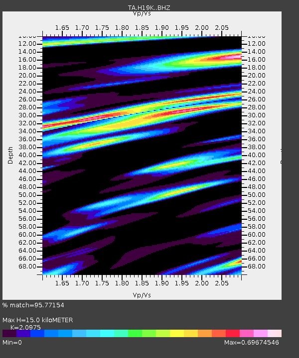
| Estimated Moho Depth: |
15.0 km |
| Estimated Crust Vp/Vs: |
2.10 |
| Assumed Crust Vp: |
6.182 km/s |
| Estimated Crust Vs: |
2.947 km/s |
| Estimated Crust Poisson's Ratio: |
0.35 |
|
| Radial Match: |
95.77154 % |
| Radial Bump: |
375 |
| Transverse Match: |
86.653755 % |
| Transverse Bump: |
400 |
| SOD ConfigId: |
13570011 |
| Insert Time: |
2019-04-29 15:40:32.552 +0000 |
| GWidth: |
2.5 |
| Max Bumps: |
400 |
| Tol: |
0.001 |
|

Signal To Noise
| Channel | StoN | STA | LTA |
| TA:H19K: :BHZ:20180124T10:58:33.875006Z | 23.662209 | 3.415846E-6 | 1.4435872E-7 |
| TA:H19K: :BHN:20180124T10:58:33.875006Z | 1.7166662 | 3.629083E-7 | 2.1140295E-7 |
| TA:H19K: :BHE:20180124T10:58:33.875006Z | 14.68222 | 2.3112993E-6 | 1.5742165E-7 |
| Arrivals |
| Ps | 2.8 SECOND |
| PpPs | 7.1 SECOND |
| PsPs/PpSs | 9.9 SECOND |


