You are here: Home > Network List > TA - USArray Transportable Network (new EarthScope stations) Stations List
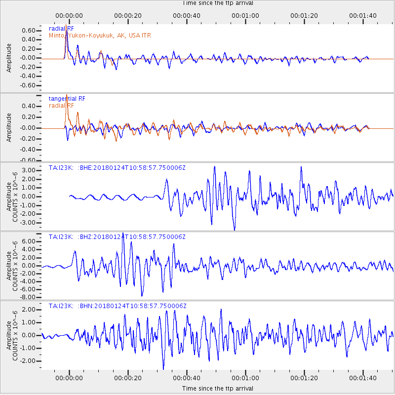
> Station I23K Minto, Yukon-Koyukuk, AK, USA > Earthquake Result Viewer
I23K Minto, Yukon-Koyukuk, AK, USA - Earthquake Result Viewer
| Earthquake location: |
Hokkaido, Japan Region |
| Earthquake latitude/longitude: |
41.1/142.3 |
| Earthquake time(UTC): |
2018/01/24 (024) 10:51:20 GMT |
| Earthquake Depth: |
40 km |
| Earthquake Magnitude: |
6.2 Mww |
| Earthquake Catalog/Contributor: |
NEIC PDE/us |
|
| Network: |
TA USArray Transportable Network (new EarthScope stations) |
| Station: |
I23K Minto, Yukon-Koyukuk, AK, USA |
| Lat/Lon: |
65.15 N/149.36 W |
| Elevation: |
149 m |
|
| Distance: |
44.6 deg |
| Az: |
33.99 deg |
| Baz: |
271.974 deg |
| Ray Param: |
0.071706384 |
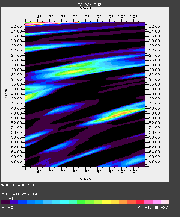
| Estimated Moho Depth: |
10.25 km |
| Estimated Crust Vp/Vs: |
1.70 |
| Assumed Crust Vp: |
6.566 km/s |
| Estimated Crust Vs: |
3.862 km/s |
| Estimated Crust Poisson's Ratio: |
0.24 |
|
| Radial Match: |
88.27802 % |
| Radial Bump: |
400 |
| Transverse Match: |
86.99767 % |
| Transverse Bump: |
400 |
| SOD ConfigId: |
13570011 |
| Insert Time: |
2019-04-29 15:40:39.029 +0000 |
| GWidth: |
2.5 |
| Max Bumps: |
400 |
| Tol: |
0.001 |
|
Signal To Noise
| Channel | StoN | STA | LTA |
| TA:I23K: :BHZ:20180124T10:58:57.750006Z | 10.830635 | 1.997089E-6 | 1.8439259E-7 |
| TA:I23K: :BHN:20180124T10:58:57.750006Z | 1.2758774 | 2.469725E-7 | 1.9357073E-7 |
| TA:I23K: :BHE:20180124T10:58:57.750006Z | 4.740435 | 9.4763215E-7 | 1.9990405E-7 |
| Arrivals |
| Ps | 1.2 SECOND |
| PpPs | 3.9 SECOND |
| PsPs/PpSs | 5.1 SECOND |


