You are here: Home > Network List > TA - USArray Transportable Network (new EarthScope stations) Stations List
> Station K15K Wolf Creek Mountain, AK, USA > Earthquake Result Viewer
K15K Wolf Creek Mountain, AK, USA - Earthquake Result Viewer
| Earthquake location: |
Hokkaido, Japan Region |
| Earthquake latitude/longitude: |
41.1/142.3 |
| Earthquake time(UTC): |
2018/01/24 (024) 10:51:20 GMT |
| Earthquake Depth: |
40 km |
| Earthquake Magnitude: |
6.2 Mww |
| Earthquake Catalog/Contributor: |
NEIC PDE/us |
|
| Network: |
TA USArray Transportable Network (new EarthScope stations) |
| Station: |
K15K Wolf Creek Mountain, AK, USA |
| Lat/Lon: |
62.29 N/161.53 W |
| Elevation: |
346 m |
|
| Distance: |
39.1 deg |
| Az: |
37.974 deg |
| Baz: |
264.035 deg |
| Ray Param: |
0.075075656 |
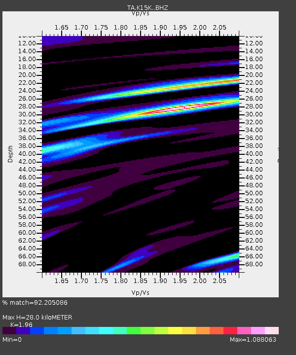
| Estimated Moho Depth: |
28.0 km |
| Estimated Crust Vp/Vs: |
1.96 |
| Assumed Crust Vp: |
6.276 km/s |
| Estimated Crust Vs: |
3.202 km/s |
| Estimated Crust Poisson's Ratio: |
0.32 |
|
| Radial Match: |
92.205086 % |
| Radial Bump: |
288 |
| Transverse Match: |
87.113365 % |
| Transverse Bump: |
388 |
| SOD ConfigId: |
13570011 |
| Insert Time: |
2019-04-29 15:40:51.069 +0000 |
| GWidth: |
2.5 |
| Max Bumps: |
400 |
| Tol: |
0.001 |
|
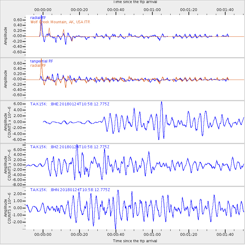
Signal To Noise
| Channel | StoN | STA | LTA |
| TA:K15K: :BHZ:20180124T10:58:12.775Z | 8.632987 | 1.9304416E-6 | 2.2361223E-7 |
| TA:K15K: :BHN:20180124T10:58:12.775Z | 1.4807361 | 3.9759703E-7 | 2.6851308E-7 |
| TA:K15K: :BHE:20180124T10:58:12.775Z | 4.649129 | 1.2717012E-6 | 2.735354E-7 |
| Arrivals |
| Ps | 4.6 SECOND |
| PpPs | 12 SECOND |
| PsPs/PpSs | 17 SECOND |


