You are here: Home > Network List > TA - USArray Transportable Network (new EarthScope stations) Stations List
> Station M26K Nabesna, AK, USA > Earthquake Result Viewer
M26K Nabesna, AK, USA - Earthquake Result Viewer
| Earthquake location: |
Hokkaido, Japan Region |
| Earthquake latitude/longitude: |
41.1/142.3 |
| Earthquake time(UTC): |
2018/01/24 (024) 10:51:20 GMT |
| Earthquake Depth: |
40 km |
| Earthquake Magnitude: |
6.2 Mww |
| Earthquake Catalog/Contributor: |
NEIC PDE/us |
|
| Network: |
TA USArray Transportable Network (new EarthScope stations) |
| Station: |
M26K Nabesna, AK, USA |
| Lat/Lon: |
62.40 N/143.00 W |
| Elevation: |
888 m |
|
| Distance: |
47.7 deg |
| Az: |
37.375 deg |
| Baz: |
280.024 deg |
| Ray Param: |
0.0697143 |
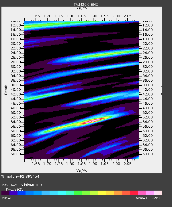
| Estimated Moho Depth: |
53.5 km |
| Estimated Crust Vp/Vs: |
1.89 |
| Assumed Crust Vp: |
6.566 km/s |
| Estimated Crust Vs: |
3.47 km/s |
| Estimated Crust Poisson's Ratio: |
0.31 |
|
| Radial Match: |
92.895454 % |
| Radial Bump: |
315 |
| Transverse Match: |
72.23325 % |
| Transverse Bump: |
400 |
| SOD ConfigId: |
13570011 |
| Insert Time: |
2019-04-29 15:41:14.100 +0000 |
| GWidth: |
2.5 |
| Max Bumps: |
400 |
| Tol: |
0.001 |
|

Signal To Noise
| Channel | StoN | STA | LTA |
| TA:M26K: :BHZ:20180124T10:59:22.074988Z | 4.0574455 | 1.1008082E-6 | 2.713057E-7 |
| TA:M26K: :BHN:20180124T10:59:22.074988Z | 1.575145 | 2.603093E-7 | 1.6526053E-7 |
| TA:M26K: :BHE:20180124T10:59:22.074988Z | 4.207336 | 5.645143E-7 | 1.3417382E-7 |
| Arrivals |
| Ps | 7.7 SECOND |
| PpPs | 22 SECOND |
| PsPs/PpSs | 30 SECOND |


