You are here: Home > Network List > TA - USArray Transportable Network (new EarthScope stations) Stations List
> Station N20K Mount Spurr, AK, USA > Earthquake Result Viewer
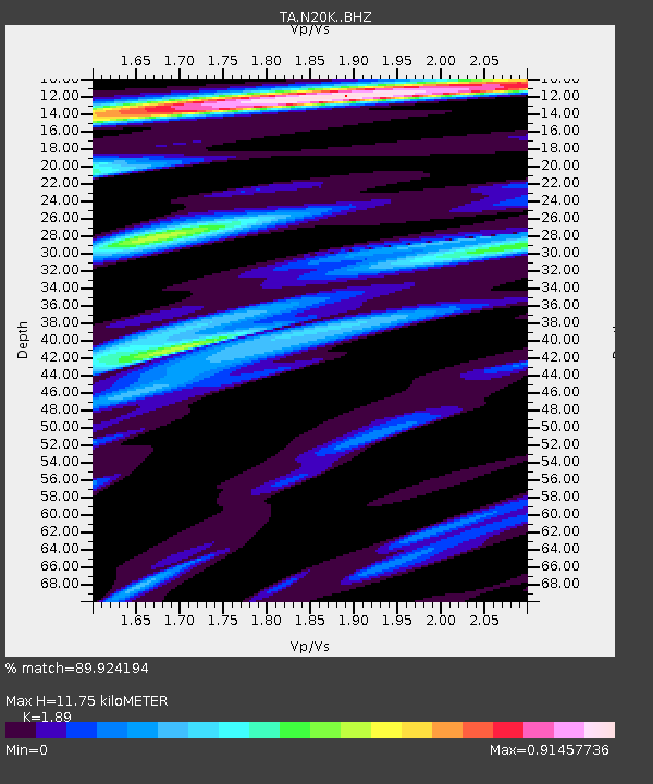
N20K Mount Spurr, AK, USA - Earthquake Result Viewer
| Earthquake location: |
Hokkaido, Japan Region |
| Earthquake latitude/longitude: |
41.1/142.3 |
| Earthquake time(UTC): |
2018/01/24 (024) 10:51:20 GMT |
| Earthquake Depth: |
40 km |
| Earthquake Magnitude: |
6.2 Mww |
| Earthquake Catalog/Contributor: |
NEIC PDE/us |
|
| Network: |
TA USArray Transportable Network (new EarthScope stations) |
| Station: |
N20K Mount Spurr, AK, USA |
| Lat/Lon: |
61.20 N/152.21 W |
| Elevation: |
991 m |
|
| Distance: |
43.5 deg |
| Az: |
39.769 deg |
| Baz: |
273.588 deg |
| Ray Param: |
0.07239458 |
| Estimated Moho Depth: |
11.75 km |
| Estimated Crust Vp/Vs: |
1.89 |
| Assumed Crust Vp: |
6.566 km/s |
| Estimated Crust Vs: |
3.474 km/s |
| Estimated Crust Poisson's Ratio: |
0.31 |
|
| Radial Match: |
89.924194 % |
| Radial Bump: |
400 |
| Transverse Match: |
73.89151 % |
| Transverse Bump: |
400 |
| SOD ConfigId: |
13570011 |
| Insert Time: |
2019-04-29 15:41:24.662 +0000 |
| GWidth: |
2.5 |
| Max Bumps: |
400 |
| Tol: |
0.001 |
|

Signal To Noise
| Channel | StoN | STA | LTA |
| TA:N20K: :BHZ:20180124T10:58:48.875006Z | 4.535196 | 1.5225746E-6 | 3.357241E-7 |
| TA:N20K: :BHN:20180124T10:58:48.875006Z | 0.92073095 | 3.8039602E-7 | 4.1314567E-7 |
| TA:N20K: :BHE:20180124T10:58:48.875006Z | 2.5941489 | 6.7327557E-7 | 2.5953622E-7 |
| Arrivals |
| Ps | 1.7 SECOND |
| PpPs | 4.8 SECOND |
| PsPs/PpSs | 6.5 SECOND |


