You are here: Home > Network List > TA - USArray Transportable Network (new EarthScope stations) Stations List
> Station N23A Red Feather Lakes, CO, USA > Earthquake Result Viewer
N23A Red Feather Lakes, CO, USA - Earthquake Result Viewer

| Earthquake location: |
Hokkaido, Japan Region |
| Earthquake latitude/longitude: |
41.1/142.3 |
| Earthquake time(UTC): |
2018/01/24 (024) 10:51:20 GMT |
| Earthquake Depth: |
40 km |
| Earthquake Magnitude: |
6.2 Mww |
| Earthquake Catalog/Contributor: |
NEIC PDE/us |
|
| Network: |
TA USArray Transportable Network (new EarthScope stations) |
| Station: |
N23A Red Feather Lakes, CO, USA |
| Lat/Lon: |
40.89 N/105.94 W |
| Elevation: |
2458 m |
|
| Distance: |
77.6 deg |
| Az: |
46.129 deg |
| Baz: |
314.074 deg |
| Ray Param: |
0.050155997 |
| Estimated Moho Depth: |
45.0 km |
| Estimated Crust Vp/Vs: |
1.95 |
| Assumed Crust Vp: |
6.306 km/s |
| Estimated Crust Vs: |
3.234 km/s |
| Estimated Crust Poisson's Ratio: |
0.32 |
|
| Radial Match: |
84.83175 % |
| Radial Bump: |
400 |
| Transverse Match: |
65.12576 % |
| Transverse Bump: |
400 |
| SOD ConfigId: |
13570011 |
| Insert Time: |
2019-04-29 15:41:27.161 +0000 |
| GWidth: |
2.5 |
| Max Bumps: |
400 |
| Tol: |
0.001 |
|
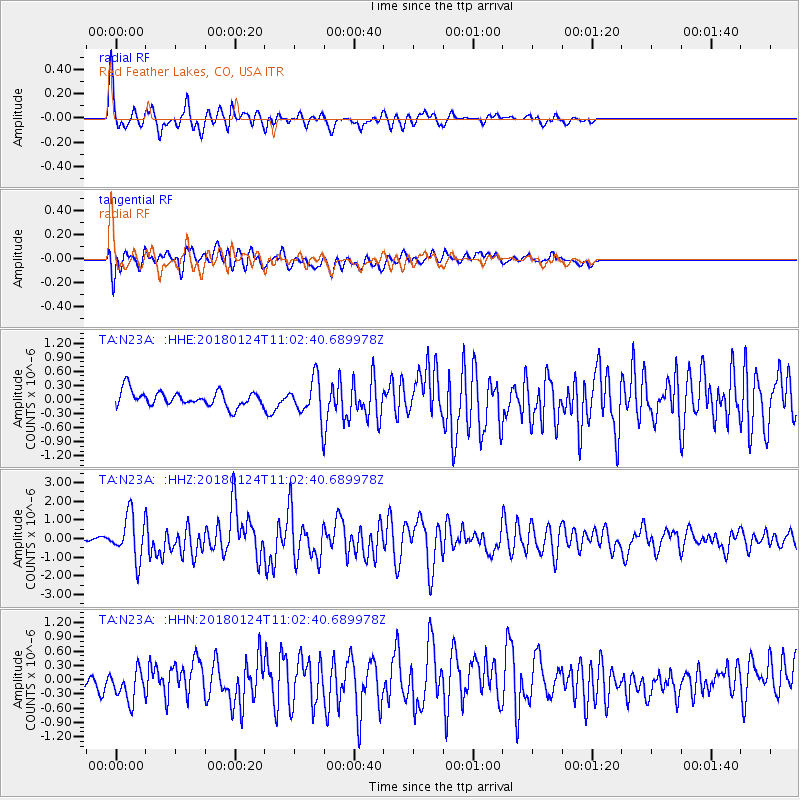
Signal To Noise
| Channel | StoN | STA | LTA |
| TA:N23A: :HHZ:20180124T11:02:40.689978Z | 8.758965 | 1.1780102E-6 | 1.3449194E-7 |
| TA:N23A: :HHN:20180124T11:02:40.689978Z | 1.789653 | 3.7098272E-7 | 2.0729311E-7 |
| TA:N23A: :HHE:20180124T11:02:40.689978Z | 2.910242 | 4.991292E-7 | 1.715078E-7 |
| Arrivals |
| Ps | 7.0 SECOND |
| PpPs | 21 SECOND |
| PsPs/PpSs | 27 SECOND |


