You are here: Home > Network List > TA - USArray Transportable Network (new EarthScope stations) Stations List
> Station N31M Braeburn, Yukon, CA > Earthquake Result Viewer
N31M Braeburn, Yukon, CA - Earthquake Result Viewer
| Earthquake location: |
Hokkaido, Japan Region |
| Earthquake latitude/longitude: |
41.1/142.3 |
| Earthquake time(UTC): |
2018/01/24 (024) 10:51:20 GMT |
| Earthquake Depth: |
40 km |
| Earthquake Magnitude: |
6.2 Mww |
| Earthquake Catalog/Contributor: |
NEIC PDE/us |
|
| Network: |
TA USArray Transportable Network (new EarthScope stations) |
| Station: |
N31M Braeburn, Yukon, CA |
| Lat/Lon: |
61.49 N/135.78 W |
| Elevation: |
716 m |
|
| Distance: |
51.3 deg |
| Az: |
37.521 deg |
| Baz: |
286.48 deg |
| Ray Param: |
0.06743942 |
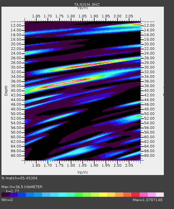
| Estimated Moho Depth: |
36.5 km |
| Estimated Crust Vp/Vs: |
1.77 |
| Assumed Crust Vp: |
6.419 km/s |
| Estimated Crust Vs: |
3.627 km/s |
| Estimated Crust Poisson's Ratio: |
0.27 |
|
| Radial Match: |
85.45384 % |
| Radial Bump: |
400 |
| Transverse Match: |
72.338715 % |
| Transverse Bump: |
400 |
| SOD ConfigId: |
13570011 |
| Insert Time: |
2019-04-29 15:41:27.886 +0000 |
| GWidth: |
2.5 |
| Max Bumps: |
400 |
| Tol: |
0.001 |
|

Signal To Noise
| Channel | StoN | STA | LTA |
| TA:N31M: :BHZ:20180124T10:59:48.949988Z | 7.0437355 | 1.2111202E-6 | 1.7194289E-7 |
| TA:N31M: :BHN:20180124T10:59:48.949988Z | 0.66261965 | 1.8986844E-7 | 2.8654213E-7 |
| TA:N31M: :BHE:20180124T10:59:48.949988Z | 2.7663505 | 5.181719E-7 | 1.8731244E-7 |
| Arrivals |
| Ps | 4.6 SECOND |
| PpPs | 15 SECOND |
| PsPs/PpSs | 20 SECOND |


