You are here: Home > Network List > TA - USArray Transportable Network (new EarthScope stations) Stations List
> Station P29M Windy Craggy, BC, CAN > Earthquake Result Viewer
P29M Windy Craggy, BC, CAN - Earthquake Result Viewer
| Earthquake location: |
Hokkaido, Japan Region |
| Earthquake latitude/longitude: |
41.1/142.3 |
| Earthquake time(UTC): |
2018/01/24 (024) 10:51:20 GMT |
| Earthquake Depth: |
40 km |
| Earthquake Magnitude: |
6.2 Mww |
| Earthquake Catalog/Contributor: |
NEIC PDE/us |
|
| Network: |
TA USArray Transportable Network (new EarthScope stations) |
| Station: |
P29M Windy Craggy, BC, CAN |
| Lat/Lon: |
59.63 N/137.74 W |
| Elevation: |
679 m |
|
| Distance: |
50.9 deg |
| Az: |
40.169 deg |
| Baz: |
286.441 deg |
| Ray Param: |
0.067688696 |
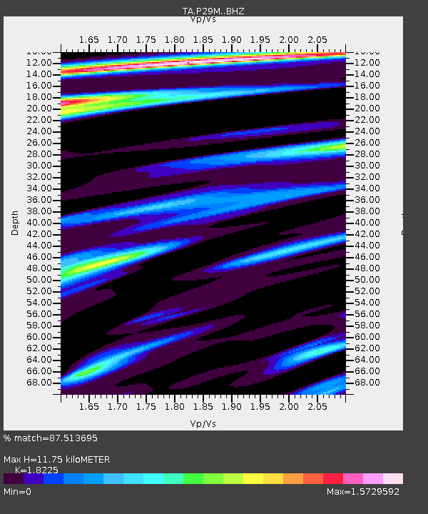
| Estimated Moho Depth: |
11.75 km |
| Estimated Crust Vp/Vs: |
1.82 |
| Assumed Crust Vp: |
6.566 km/s |
| Estimated Crust Vs: |
3.603 km/s |
| Estimated Crust Poisson's Ratio: |
0.28 |
|
| Radial Match: |
87.513695 % |
| Radial Bump: |
400 |
| Transverse Match: |
82.01672 % |
| Transverse Bump: |
400 |
| SOD ConfigId: |
13570011 |
| Insert Time: |
2019-04-29 15:41:37.850 +0000 |
| GWidth: |
2.5 |
| Max Bumps: |
400 |
| Tol: |
0.001 |
|
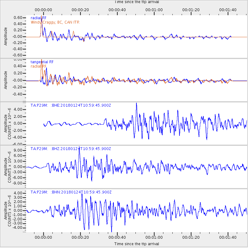
Signal To Noise
| Channel | StoN | STA | LTA |
| TA:P29M: :BHZ:20180124T10:59:45.900Z | 4.3188825 | 1.333927E-6 | 3.0885928E-7 |
| TA:P29M: :BHN:20180124T10:59:45.900Z | 1.8510071 | 5.139373E-7 | 2.7765282E-7 |
| TA:P29M: :BHE:20180124T10:59:45.900Z | 2.2556448 | 6.373031E-7 | 2.82537E-7 |
| Arrivals |
| Ps | 1.6 SECOND |
| PpPs | 4.8 SECOND |
| PsPs/PpSs | 6.3 SECOND |


