You are here: Home > Network List > TA - USArray Transportable Network (new EarthScope stations) Stations List
> Station SUSD Miller, SD, USA > Earthquake Result Viewer
SUSD Miller, SD, USA - Earthquake Result Viewer
| Earthquake location: |
Hokkaido, Japan Region |
| Earthquake latitude/longitude: |
41.1/142.3 |
| Earthquake time(UTC): |
2018/01/24 (024) 10:51:20 GMT |
| Earthquake Depth: |
40 km |
| Earthquake Magnitude: |
6.2 Mww |
| Earthquake Catalog/Contributor: |
NEIC PDE/us |
|
| Network: |
TA USArray Transportable Network (new EarthScope stations) |
| Station: |
SUSD Miller, SD, USA |
| Lat/Lon: |
44.44 N/98.96 W |
| Elevation: |
520 m |
|
| Distance: |
78.6 deg |
| Az: |
39.831 deg |
| Baz: |
317.501 deg |
| Ray Param: |
0.04943778 |
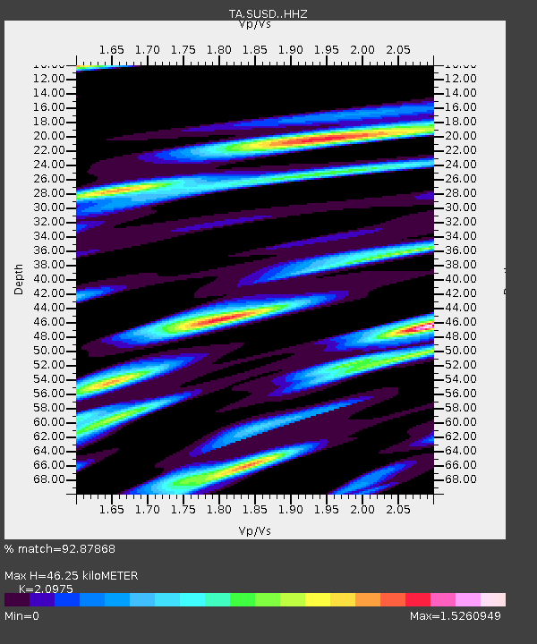
| Estimated Moho Depth: |
46.25 km |
| Estimated Crust Vp/Vs: |
2.10 |
| Assumed Crust Vp: |
6.53 km/s |
| Estimated Crust Vs: |
3.113 km/s |
| Estimated Crust Poisson's Ratio: |
0.35 |
|
| Radial Match: |
92.87868 % |
| Radial Bump: |
400 |
| Transverse Match: |
85.01909 % |
| Transverse Bump: |
400 |
| SOD ConfigId: |
13570011 |
| Insert Time: |
2019-04-29 15:41:54.491 +0000 |
| GWidth: |
2.5 |
| Max Bumps: |
400 |
| Tol: |
0.001 |
|

Signal To Noise
| Channel | StoN | STA | LTA |
| TA:SUSD: :HHZ:20180124T11:02:46.579993Z | 11.89927 | 1.7591803E-6 | 1.4783936E-7 |
| TA:SUSD: :HHN:20180124T11:02:46.579993Z | 3.3285682 | 1.0696201E-6 | 3.213454E-7 |
| TA:SUSD: :HHE:20180124T11:02:46.579993Z | 5.198406 | 1.3260511E-6 | 2.55088E-7 |
| Arrivals |
| Ps | 8.0 SECOND |
| PpPs | 21 SECOND |
| PsPs/PpSs | 29 SECOND |


